IMAGES TAKEN NEAR TO
Joyce Avenue, NOTTINGHAM, NG5 3HN
Introduction
This page details the photographs taken nearby to Joyce Avenue, NG5 3HN by members of the Geograph project.
The Geograph project started in 2005 with the aim of publishing, organising and preserving representative images for every square kilometre of Great Britain, Ireland and the Isle of Man.

There are currently over 7.5m images from over14,400 individuals and you can help contribute to the project by visiting https://www.geograph.org.uk
Image Map
Images are licensed for reuse under creativecommons.org/licenses/by-sa/2.0
Notes
- Clicking on the map will re-center to the selected point.
- The higher the marker number, the further away the image location is from the centre of the postcode.
Image Listing (74 Images Found)
Images are licensed for reuse under creativecommons.org/licenses/by-sa/2.0
Image
Details
Distance
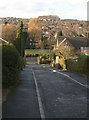
1
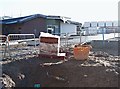
Joyce Avenue, Nottingham, NG5
The rear of the “Hopewood" NHS hub. The main entrance of this new complex is on Mansfield Road. The development will include in-patient and out-patient mental health facilities for children and adolescents and a new mother and baby unit, together with out-patient perinatal mental health facilities. It is due to open in spring 2018.
Image: © David Hallam-Jones
Taken: 26 Dec 2017
0.02 miles
2
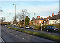
Valley Road
Constructed as a dual carriageway ring road for the city in the 1930s. Today it is a designated trunk road.
Image: © Alan Murray-Rust
Taken: 8 Mar 2009
0.07 miles
3
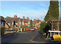
Bonnington Crescent
The Sherwood Estate was a Nottingham City Council development of the 1930s. The general layout is attractive, but roads are well below standards for today's car-driven society.
Image: © Alan Murray-Rust
Taken: 8 Mar 2009
0.07 miles
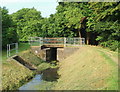
4
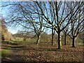
Valley Road Park
The western end of the wetlands section.
Image: © Alan Murray-Rust
Taken: 26 Jan 2022
0.10 miles
5
Barnby Walk
The Sherwood Estate was a Nottingham City Council development of the 1930s. The general layout is attractive, but roads are well below standards for today's car-driven society. Here the carriageway is no more than about 3 metres wide, but it is still a 2-way road!
Image: © Alan Murray-Rust
Taken: 8 Mar 2009
0.10 miles
6
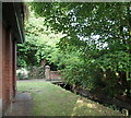
Day Brook Recreation Ground, Nottingham NG5
Here the brook passes beneath a footpath linking Mossdale Road and Valley Road (the A6514) at the side of a brick-built electricity substation.
Image: © David Hallam-Jones
Taken: 12 Jul 2014
0.11 miles
7
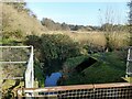
The Day Brook in Valley Road Park
This section was converted from grassland to a water meadow in around 2008 as a flood alleviation measure. Previously the brook ran in a narrow straight channel along the line of the hedge to the left. The structure in the foreground previously acted to reduce flow to some extent.
Image: © Alan Murray-Rust
Taken: 26 Jan 2022
0.11 miles
8
Day Brook Recreation Ground, Nottingham NG5
With the eastern-most entrance/exit to the park near the junction of Mansfield Road and Valley Road no more than 5 minutes walk away behind the photographer, this is the view towards the midpoint of this long, thin (sausage-shaped) recreation ground. Several bowling greens lie 300-400 metres ahead on the other side of this cross-over point.
Image: © David Hallam-Jones
Taken: 12 Jul 2014
0.11 miles
9
Day Brook Recreation Ground, Nottingham NG5
Midway between the bowling greens (behind the photographer) and where this footpath begins (or ends), near the junction of Valley Road with Mansfield Road, the footpath crosses the brook.
Image: © David Hallam-Jones
Taken: 12 Jul 2014
0.11 miles
10
Day Brook Recreation Ground, Nottingham NG5
With the eastern-most entrance/exit to the park near to the junction of Mansfield Road and Valley Road 5 minutes walk away behind the photographer this is the view towards the midpoint of this long, thin (sausage-shaped) recreation ground. Several bowling greens lie 300-400 metres ahead on the other side of this cross-over point.
Image: © David Hallam-Jones
Taken: 12 Jul 2014
0.11 miles