IMAGES TAKEN NEAR TO
Ennerdale Road, NOTTINGHAM, NG5 3GP
Introduction
This page details the photographs taken nearby to Ennerdale Road, NG5 3GP by members of the Geograph project.
The Geograph project started in 2005 with the aim of publishing, organising and preserving representative images for every square kilometre of Great Britain, Ireland and the Isle of Man.

There are currently over 7.5m images from over14,400 individuals and you can help contribute to the project by visiting https://www.geograph.org.uk
Image Map
Images are licensed for reuse under creativecommons.org/licenses/by-sa/2.0
Notes
- Clicking on the map will re-center to the selected point.
- The higher the marker number, the further away the image location is from the centre of the postcode.
Image Listing (55 Images Found)
Images are licensed for reuse under creativecommons.org/licenses/by-sa/2.0
Image
Details
Distance
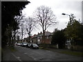
1
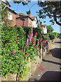
Daybrook: a summer morning in Ennerdale Road
Image: © John Sutton
Taken: 25 Jun 2013
0.02 miles
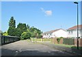
2
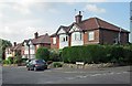
Daybrook: Ennerdale Road
A view from the corner of Bedale Road.
Image: © John Sutton
Taken: 25 Jun 2013
0.03 miles
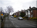
4
Road block on Ribblesdale Road
Instituted many years ago to prevent the use of the road as a rat run.
Image: © Alan Murray-Rust
Taken: 26 Jan 2022
0.06 miles
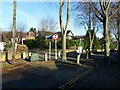
5
Daybrook: houses where trains once ran
The houses of Longdale Road are built on the site of Daybrook Station, on the Great Northern line to Derby. Daybrook Station and the section of the line between Basford North and Gedling closed in April 1960 when Mapperley Tunnel was declared unsafe.
Image: © John Sutton
Taken: 25 Jun 2013
0.07 miles
7

Hazel catkins
Due to the warm autumn, the catkins are well advanced even before all the leaves have fallen.
Image: © Alan Murray-Rust
Taken: 2 Dec 2022
0.09 miles
8
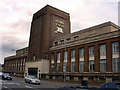
Home Brewery buildings, Daybrook
Now council offices
Image: © Q
Taken: 14 Jun 2005
0.09 miles
9
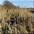
Typha latifolia and phragmites australis
Growing close together in Valley Road Park – a view for comparison of the two species. Typha in the foreground with phragmites behind.
Image: © Alan Murray-Rust
Taken: 26 Jan 2022
0.10 miles
10
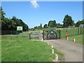
Sherwood/Daybrook: Peggy's Park
The gate, designed by young people from Edwards Lane Community Centre, reflects the place's relatively recent past, as part of the Great Northern Railway's Nottingham-Derby railway, known as the Back Line. An information board gives a good potted history of the line, with pictures.
Though in the Sherwood area of the City of Nottingham, the park is not far from the site of Daybrook Station.
Image: © John Sutton
Taken: 25 Jun 2013
0.10 miles