IMAGES TAKEN NEAR TO
Trevose Gardens, NOTTINGHAM, NG5 3FU
Introduction
This page details the photographs taken nearby to Trevose Gardens, NG5 3FU by members of the Geograph project.
The Geograph project started in 2005 with the aim of publishing, organising and preserving representative images for every square kilometre of Great Britain, Ireland and the Isle of Man.

There are currently over 7.5m images from over14,400 individuals and you can help contribute to the project by visiting https://www.geograph.org.uk
Image Map
Images are licensed for reuse under creativecommons.org/licenses/by-sa/2.0
Notes
- Clicking on the map will re-center to the selected point.
- The higher the marker number, the further away the image location is from the centre of the postcode.
Image Listing (77 Images Found)
Images are licensed for reuse under creativecommons.org/licenses/by-sa/2.0
Image
Details
Distance
1
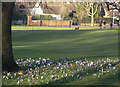
Crocuses in Woodthorpe Grange Park
Adding welcome colour after the drabness of winter.
Image: © Alan Murray-Rust
Taken: 8 Mar 2009
0.05 miles
2
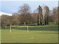
Woodthorpe Grange Park
The view from near mansfield Road. Football field in the foreground, pitch and putt beyond. The slope is for real - even the birch trees are not upright!
Image: © Alan Murray-Rust
Taken: 8 Mar 2009
0.05 miles
3
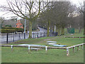
Odd objects in the park
As far as I can make out, these are part of the water supply network. There are lot of valve covers as well as what appear to be vents or hatches. The green box beyond describes itself as a booster pumping station.
Image: © Alan Murray-Rust
Taken: 8 Mar 2009
0.06 miles
4
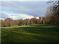
Woodthorpe Grange Park
General view from the gate on Mansfield Road, with lengthening afternoon shadows.
Image: © Alan Murray-Rust
Taken: 8 Mar 2009
0.06 miles
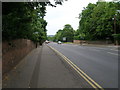
6
Woodthorpe Drive
This road forms the boundary between Gedling Borough (left) and Nottingham City (right), which then turns left up the centre of Mansfield Road.
Image: © Alan Murray-Rust
Taken: 8 Mar 2009
0.07 miles
7
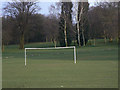
Goal!
In Woodthorpe Grange Park. The ground really does slope as sharply as the picture suggests - even the birch trees are not upright.
Image: © Alan Murray-Rust
Taken: 8 Mar 2009
0.07 miles
8
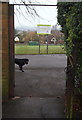
Nottingham, NG5 - Sherwood
A secondary entrance/exit into Woodthorpe Grange Park from "The Rise", off Elmswood Gardens.The boundary fence on the opposite side of the park that faces the houses on Woodthorpe Drive forms the boundary line between the jursidictions of Nottingham Council and Gedling Council.
Image: © David Hallam-Jones
Taken: 24 Nov 2012
0.08 miles
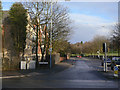
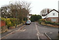
9
Nottingham, NG5 - Sherwood
An alley used by pedestrians to exit Woodthorpe Grange Park and out onto the top-bar section of a T-shaped cul-de-sac known as "The Rise", that is off Elmswood Gardens.
Image: © David Hallam-Jones
Taken: 24 Nov 2012
0.08 miles
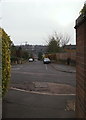
10
Nottingham, NG5 - Sherwood
The top bar of a T-shaped cul-de-sac known as "The Rise", off Elmswood Gardens. Just visible in front of the street light is an alley leading towards a secondary entrance into Woodthorpe Grange Park.
Image: © David Hallam-Jones
Taken: 24 Nov 2012
0.08 miles