IMAGES TAKEN NEAR TO
Mansfield Road, NOTTINGHAM, NG5 3FG
Introduction
This page details the photographs taken nearby to Mansfield Road, NG5 3FG by members of the Geograph project.
The Geograph project started in 2005 with the aim of publishing, organising and preserving representative images for every square kilometre of Great Britain, Ireland and the Isle of Man.

There are currently over 7.5m images from over14,400 individuals and you can help contribute to the project by visiting https://www.geograph.org.uk
Image Map (Loading...)


Getting Data...Please wait
Leaflet Map data © OpenStreetMap
Images are licensed for reuse under creativecommons.org/licenses/by-sa/2.0
Notes
- Clicking on the map will re-center to the selected point.
- The higher the marker number, the further away the image location is from the centre of the postcode.
Image Listing (64 Images Found)
Images are licensed for reuse under creativecommons.org/licenses/by-sa/2.0
Image
Details
Distance
1
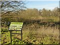
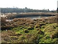
Valley Road Water Meadow
Created by diverting the Day Brook to a meandering course with small ponds in around 2008 as a flood alleviation scheme, the area has developed more of a wetland ecology with extensive reed-beds. The intention of attracting more diverse wildlife, as indicated on the board, has however been fulfilled.
Image: © Alan Murray-Rust
Taken: 26 Jan 2022
0.09 miles
2
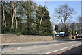
Entrance to Hopewood Hospital from Mansfield Road
There is an Ordnance Survey benchmark Image on a base stone in the wall (the 10th stone from the left hand edge of the image)
Image: © Luke Shaw
Taken: 1 Apr 2019
0.09 miles
3
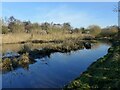
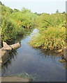
The Day Brook in Valley Road Park
A pond-like section with wetland characteristics.
Image: © Alan Murray-Rust
Taken: 26 Jan 2022
0.09 miles
4
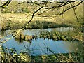
The Day Brook in Valley Road Park
A pond-like section with wetland characteristics.
Image: © Alan Murray-Rust
Taken: 26 Jan 2022
0.09 miles
5
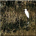
Wildlife in Valley Road Park
I was very surprised to find a Little Egret and a pair of Teal (note the green flash of the male top left) in what is still very much an urban environment.
Image: © Alan Murray-Rust
Taken: 26 Jan 2022
0.10 miles
6

Benchmark on Mansfield Road wall bounding Hopewood Hospital
Ordnance Survey cut mark benchmark described on the Bench Mark Database at www.bench-marks.org.uk/bm114816
Image: © Luke Shaw
Taken: 1 Apr 2019
0.11 miles
7
The Day Brook in Valley Road Park
These stepping stones across the brook are not entirely comfortable to use.
Image: © Alan Murray-Rust
Taken: 26 Jan 2022
0.11 miles
8
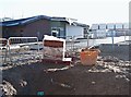
Joyce Avenue, Nottingham, NG5
The rear of the “Hopewood" NHS hub. The main entrance of this new complex is on Mansfield Road. The development will include in-patient and out-patient mental health facilities for children and adolescents and a new mother and baby unit, together with out-patient perinatal mental health facilities. It is due to open in spring 2018.
Image: © David Hallam-Jones
Taken: 26 Dec 2017
0.12 miles
9
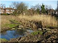
Pond in Valley Road Park
Part of the most easterly section of this linear park which has been allowed to develop a natural wetland habitat.
Image: © Alan Murray-Rust
Taken: 26 Jan 2022
0.13 miles
10
Valley Road Park, Nottingham NG5
The Day Brook, seen from the stepping stones near to the Valley Rd/Mansfield Rd park entrance, meanders through the flood plain area of this precious green space.
Image: © David Hallam-Jones
Taken: 12 Jul 2014
0.13 miles