1
Danethorpe Vale
Leading up into Sherwood Estate from Valley Road.
Image: © Alan Murray-Rust
Taken: 8 Mar 2009
0.02 miles
2
Day Brook Recreation Ground, Nottingham NG5
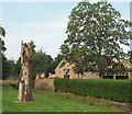
A face carved on the remains of a tree in this recreation ground. The latter is situated across the brook from the Five Ways Hotel (a.k.a. "The Fivvies") on Edwards Lane. This 'Brewer's Tudor' style pub was designed in c.1936 by A.E. Eberlin of Nottingham for Warwicks & Richardsons (Brewers). It is Grade II listed.
Image: © David Hallam-Jones
Taken: 12 Jul 2014
0.09 miles
3
Slime mould growing on dead wood
On this fallen tree stump https://www.geograph.org.uk/photo/7355947 .
Image: © Alan Murray-Rust
Taken: 2 Dec 2022
0.09 miles
4
Day Brook near Edwards Lane, Nottingham NG5
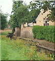
The terrace of the Five Ways Hotel (a.k.a. "The Fivvies") is seen here on the other side of the brook. This Grade II-listed pub was designed by A. E. Eberlin of Nottingham in c.1936 for Warwicks & Richardsons (Brewers). The brook passes beneath Edwards Lane here before it continues to run parallel with Valley Road (the A6514), forming as it does so, the southern boundary of the grounds of the City Hospital.
Image: © David Hallam-Jones
Taken: 12 Jul 2014
0.09 miles
5
Day Brook Recreation Ground, Nottingham NG5
The Day Brook at the side of the Five Ways Hotel, Edwards Lane. Valley Road (the A6514) is situated immediately behind the trees on the right.
Image: © David Hallam-Jones
Taken: 12 Jul 2014
0.10 miles
6
Five Ways Island
The crossing of Valley Road (Nottingham's ring road) with Edward's Lane, a major artery into outer housing estates.
Image: © Alan Murray-Rust
Taken: 8 Mar 2009
0.10 miles
7
Day Brook at 5 Ways
This stream has been heavily managed as a result of urban development.
Image: © Alan Murray-Rust
Taken: 8 Mar 2009
0.10 miles
8
Top of a tree stump
The rotting wood has been attacked by boring creatures of varying sizes.
Image: © Alan Murray-Rust
Taken: 18 Jan 2022
0.10 miles
9
Old man in the tree
Carving in a tree stump in Valley Road Park.
Image: © Alan Murray-Rust
Taken: 18 Jan 2022
0.10 miles
10
Benchmark on bridge, Edwards Lane
Ordnance Survey cut mark benchmark described on the Bench Mark Database at http://www.bench-marks.org.uk/bm42686
Image: © Roger Templeman
Taken: 9 Apr 2012
0.10 miles


