IMAGES TAKEN NEAR TO
Montfort Crescent, NOTTINGHAM, NG5 3EH
Introduction
This page details the photographs taken nearby to Montfort Crescent, NG5 3EH by members of the Geograph project.
The Geograph project started in 2005 with the aim of publishing, organising and preserving representative images for every square kilometre of Great Britain, Ireland and the Isle of Man.

There are currently over 7.5m images from over14,400 individuals and you can help contribute to the project by visiting https://www.geograph.org.uk
Image Map
Images are licensed for reuse under creativecommons.org/licenses/by-sa/2.0
Notes
- Clicking on the map will re-center to the selected point.
- The higher the marker number, the further away the image location is from the centre of the postcode.
Image Listing (46 Images Found)
Images are licensed for reuse under creativecommons.org/licenses/by-sa/2.0
Image
Details
Distance
1
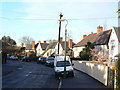
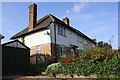
Montfort Crescent
The Sherwood Estate was a Nottingham City Council development of the 1930s. The general layout is attractive, but roads are well below standards for today's car-driven society.
Image: © Alan Murray-Rust
Taken: 8 Mar 2009
0.06 miles
2
Nos. 24 and 22 Tithby Drive
There is an Ordnance Survey benchmark Image on the corner, left hand face, of the nearer house, right of a black downpipe
Image: © Luke Shaw
Taken: 1 Apr 2019
0.07 miles
3
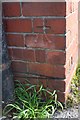
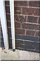
Benchmark on No. 24 Tithby Drive
Ordnance Survey cut mark benchmark described on the Bench Mark Database at www.bench-marks.org.uk/bm114819
Image: © Luke Shaw
Taken: 1 Apr 2020
0.07 miles
4
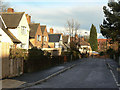
Tithby Drive
The Sherwood Estate was a Nottingham City Council development of the 1930s. The general layout is attractive, but roads are well below standards for today's car-driven society.
Image: © Alan Murray-Rust
Taken: 8 Mar 2009
0.08 miles
5
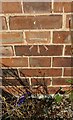
Benchmark on No. 718 Mansfield Road
Ordnance Survey cut mark benchmark described on the Bench Mark Database at www.bench-marks.org.uk/bm114820
Image: © Luke Shaw
Taken: 1 Apr 2019
0.09 miles
6
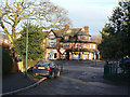
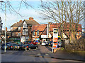
Shops on Mansfield Road
The small group of shops below Woodthorpe Drive have not succumbed totally to takeaway hairdressers or estate agents! The main trade will come from the Sherwood Estate which is accessible down Hawksworth Avenue where the photographer is standing.
Image: © Alan Murray-Rust
Taken: 8 Mar 2009
0.09 miles
7
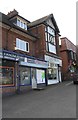
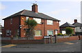
No. 718 Mansfield Road (Polished Nails and Beauty) and neighbouring businesses
There is an Ordnance Survey benchmark Image on the far side of the nails salon at its front corner
Image: © Luke Shaw
Taken: 1 Apr 2019
0.09 miles
8
Benchmark on No. 1 Tithby Drive
Ordnance Survey cut mark benchmark described on the Bench Mark Database at www.bench-marks.org.uk/bm114818
Image: © Luke Shaw
Taken: 1 Apr 2020
0.09 miles
9
Nos.1 and 3 Tithby Drive
There is an Ordnance Survey benchmark Image on the nearer house, on its side just through the wooden gate
Image: © Luke Shaw
Taken: 1 Apr 2019
0.09 miles
10
Local shops
A small parade on Mansfield Road near Woodthorpe Drive, very convenient for the tween-wars Sherwood Estate on the west side of mansfield Road.
Image: © Alan Murray-Rust
Taken: 8 Mar 2009
0.10 miles