IMAGES TAKEN NEAR TO
Mansfield Road, NOTTINGHAM, NG5 2JN
Introduction
This page details the photographs taken nearby to Mansfield Road, NG5 2JN by members of the Geograph project.
The Geograph project started in 2005 with the aim of publishing, organising and preserving representative images for every square kilometre of Great Britain, Ireland and the Isle of Man.

There are currently over 7.5m images from over14,400 individuals and you can help contribute to the project by visiting https://www.geograph.org.uk
Image Map
Images are licensed for reuse under creativecommons.org/licenses/by-sa/2.0
Notes
- Clicking on the map will re-center to the selected point.
- The higher the marker number, the further away the image location is from the centre of the postcode.
Image Listing (109 Images Found)
Images are licensed for reuse under creativecommons.org/licenses/by-sa/2.0
Image
Details
Distance
1
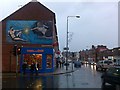
Michelangelo Mural
On the junction of Winchester Street and Mansfield Road in the Sherwood district.
Image: © David Lally
Taken: 30 Dec 2009
0.03 miles
2
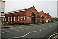
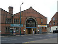
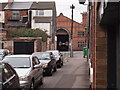
Former Sherwood Bus Depot
Situated on the northing this building constructed as the Sherwood depot for Nottingham City Transport and would have originally housed the trams which plied Mansfield Road into the city. Nowadays the nearest wing in an activity centre whilst the furthest is a pub.
Image: © Mick Garratt
Taken: 5 Jan 2007
0.03 miles
3
Sherwood Tram Depot
Built in 1900, it saw the commencement of Nottingham's electric trams in 1901. Trams ran from here until the system closed in 1936 when it became a bus garage. The increasing size of buses meant that it was more and more difficult to use as a bus depot and it closed in the late 1980s. There were proposals to convert it into a supermarket, but its listed building status meant that the chain involved could not produce a satisfactory solution that would not involve major structural changes. Now it is again housing buses, but these are the smaller ones run by Nottingham Community Transport, providing services to the less mobile. Half the northern bay has been converted into a pub, and the former staff facilities at the rear are used for various community activities.
Image: © Alan Murray-Rust
Taken: 15 Mar 2009
0.04 miles
5
the Oak Tree
New pub created in part of the former Sherwood Tram Depot.
Image: © Alan Murray-Rust
Taken: 15 Mar 2009
0.04 miles
7
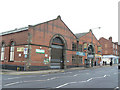
Sherwood Bus Depot at Melrose Street / Mansfield Road junction
There is an Ordnance Survey benchmark Image on the second quoin above the pavement of Melrose Street, right of a road sign pole.
Image: © Luke Shaw
Taken: 1 Apr 2019
0.04 miles
8
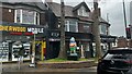
Sherwood: Winchester Terrace
Terraced houses with front gardens separated by an entry.
Image: © John Sutton
Taken: 17 Jun 2014
0.04 miles
9
Nottingham - Sherwood NG5
A view of the former Nottingham City Transport Bus Depot on Mansfield Rd (A60) from Marshall St. Prior to being a bus depot it was the local tram depot. The old sheds are now split, 3/4 of them being used as a city council mini-bus depot and the remaining 1/4 as a Wetherspoon's pub. The area at the back of the depot that was once used as offices, rest areas and a cafeteria etc are now used as base for arts & community groups. This recreational area is now called "The Place" and is run by the Sherwood Depot Action Group.
Image: © David Hallam-Jones
Taken: 16 Mar 2012
0.05 miles
10
Damaged benchmark on Sherwood Bus Depot
Ordnance Survey cut mark benchmark described on the Bench Mark Database at www.bench-marks.org.uk/bm52796
Image: © Luke Shaw
Taken: 1 Apr 2019
0.05 miles