
IMAGES TAKEN NEAR TO
Cannon Street, NOTTINGHAM, NG5 2HB
Introduction
This page details the photographs taken nearby to Cannon Street, NG5 2HB by members of the Geograph project.
The Geograph project started in 2005 with the aim of publishing, organising and preserving representative images for every square kilometre of Great Britain, Ireland and the Isle of Man.

There are currently over 7.5m images from over14,400 individuals and you can help contribute to the project by visiting https://www.geograph.org.uk
Image Map
Images are licensed for reuse under creativecommons.org/licenses/by-sa/2.0
Notes
- Clicking on the map will re-center to the selected point.
- The higher the marker number, the further away the image location is from the centre of the postcode.
Image Listing (105 Images Found)
Images are licensed for reuse under creativecommons.org/licenses/by-sa/2.0
Image
Details
Distance
1
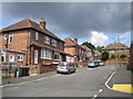
North end of Cannon Street, Sherwood
The northern end of Cannon Street, seen here from the end of St Albans Street, forms a short cul de sac serving houses that appear to be rather more modern than the Edwardian housing that typifies this part of Sherwood.
Image: © Richard Vince
Taken: 14 Jul 2012
0.03 miles
2
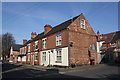
Houses on Daybrook Street at Woodville Road junction
There is an Ordnance Survey benchmark Image on the corner, right hand face, of the nearest house
Image: © Luke Shaw
Taken: 1 Apr 2019
0.03 miles
3
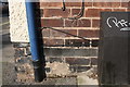
Benchmark on No. 36 Daybrook Street (Woodville Road face)
Ordnance Survey cut mark benchmark described on the Bench Mark Database at www.bench-marks.org.uk/bm1148113
Image: © Luke Shaw
Taken: 1 Apr 2019
0.04 miles
4
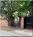
Sherwood NG5, Nottingham.
The Woodville Drive end of a twitchell - or alleyway - that links this cul-de-sac with Rufford Road, another cul-de-sac at its Sherwood shopping centre end.(The word "twychel" dates back to the C15th).
Image: © David Hallam-Jones
Taken: 13 Jun 2013
0.06 miles
5
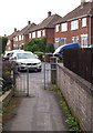
Sherwood NG5, Nottingham.
Woodville Drive lies 50 metres behind the photographer. This is Rufford Road, a cul-de-sac, seen from the connecting twitchell, i.e. alleyway. The word "twychel" dates back to the C15th.
Image: © David Hallam-Jones
Taken: 13 Jun 2013
0.06 miles
6

Hardwick Road, Sherwood
A road into the leafy enclave immediately north west of Sherwood shopping centre, seen from the end of Newstead Street.
Image: © Richard Vince
Taken: 14 Jul 2012
0.10 miles
7
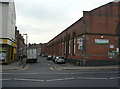
Melrose Street
Looking down the side of the former Sherwood Tram Depot
Image: © Alan Murray-Rust
Taken: 15 Mar 2009
0.10 miles
8
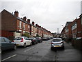
Eastern half of Crossman Street, Sherwood
The eastern half of Crossman Street, Sherwood, just after midday on Christmas Day 2012. One of the high rise blocks of flats in Woodthorpe is just visible in the distance.
Image: © Richard Vince
Taken: 25 Dec 2012
0.10 miles
10
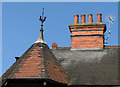
Watson Fothergill's Elberton House, Hardwick Road - 3
Elberton House, on the corner of Hardwick and Hartington Roads, dates from 1890 and includes a full range of characteristic Fothergill features, such as the octagonal corner turret with spiky finial, tiles, terra cotta and fine red brick.
Image: © John Sutton
Taken: 18 May 2010
0.11 miles