IMAGES TAKEN NEAR TO
Percival Road, NOTTINGHAM, NG5 2EY
Introduction
This page details the photographs taken nearby to Percival Road, NG5 2EY by members of the Geograph project.
The Geograph project started in 2005 with the aim of publishing, organising and preserving representative images for every square kilometre of Great Britain, Ireland and the Isle of Man.

There are currently over 7.5m images from over14,400 individuals and you can help contribute to the project by visiting https://www.geograph.org.uk
Image Map
Images are licensed for reuse under creativecommons.org/licenses/by-sa/2.0
Notes
- Clicking on the map will re-center to the selected point.
- The higher the marker number, the further away the image location is from the centre of the postcode.
Image Listing (141 Images Found)
Images are licensed for reuse under creativecommons.org/licenses/by-sa/2.0
Image
Details
Distance
1
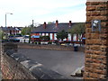
Nottingham - NG5
Haydn Road separates the previous (Victorian) school, seen at the forefront of this picture, from its replacement i.e. Haydn Road Junior and Infants School. These older premises are nonetheless still used as a teaching annexe.
Image: © David Hallam-Jones
Taken: 22 Apr 2012
0.05 miles
2
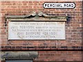
Robinson's Almshouses [2]
The plaque on the wall of the houses seen at Image
Image: © Michael Dibb
Taken: 30 Mar 2017
0.05 miles
3
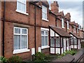
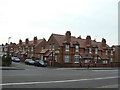
Robinson's Almshouses [1]
This delightful terrace of houses were built and endowed by John Robinson, Sheriff of Nottingham in 1889.
Image: © Michael Dibb
Taken: 30 Mar 2017
0.06 miles
4
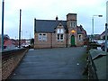
Haydn Road Primary School.
Once the main school but now just an annexe.
I seem to remember breaking my collar bone on those steps.
Image: © Mick Garratt
Taken: 3 Dec 2005
0.06 miles
5
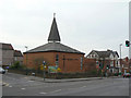
Sherwood Methodist Church
Modern church on Mansfield Road.
Image: © Alan Murray-Rust
Taken: 15 Mar 2009
0.06 miles
6
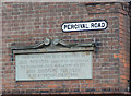
Robinson Memorial Homes, Sherwood
The only other information available is that the inhabitants received 4/- a week.
Image: © Alan Murray-Rust
Taken: 15 Mar 2009
0.06 miles
7
Robinson Memorial Homes
Mansfield Road, Sherwood. The Image foundation stone tells about as much as I can find. There is another set of homes just two street corners away.
Image: © Alan Murray-Rust
Taken: 15 Mar 2009
0.06 miles
8
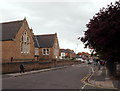
Haydn Road, Sherwood, NG5.
These are the original Victorian school buildings on Haydn Road. The main school buildings of Haydn Road Junior and Infants School are now on the right-hand side of the road behind the railings, although these older buildings are still in use as an annexe. Mansfield Road (the A60) lies 200 metres behind the photographer and Hucknall Road is situated in the distance, approximately 5 minutes walk away.
Image: © David Hallam-Jones
Taken: 13 Jun 2013
0.06 miles
9
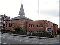
Methodist church
This pleasant, modern building is home to Sherwood Methodist church.
Image: © Michael Dibb
Taken: 30 Mar 2017
0.06 miles
10
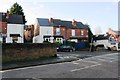
Junction of Haydn Road and Burnham Street
There is an OS benchmark Image on the right hand end of the stone wall in the middle of the image
Image: © Luke Shaw
Taken: 1 Feb 2020
0.07 miles