IMAGES TAKEN NEAR TO
Mansfield Road, NOTTINGHAM, NG5 2DL
Introduction
This page details the photographs taken nearby to Mansfield Road, NG5 2DL by members of the Geograph project.
The Geograph project started in 2005 with the aim of publishing, organising and preserving representative images for every square kilometre of Great Britain, Ireland and the Isle of Man.

There are currently over 7.5m images from over14,400 individuals and you can help contribute to the project by visiting https://www.geograph.org.uk
Image Map
Images are licensed for reuse under creativecommons.org/licenses/by-sa/2.0
Notes
- Clicking on the map will re-center to the selected point.
- The higher the marker number, the further away the image location is from the centre of the postcode.
Image Listing (169 Images Found)
Images are licensed for reuse under creativecommons.org/licenses/by-sa/2.0
Image
Details
Distance
1
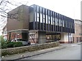
Unlovely building
Part of a skin clinic, this horrible building is unfortunately next door to the lovely Gregory House building Image and across the road from St John's Church Image
Image: © Michael Dibb
Taken: 30 Mar 2017
0.00 miles
2
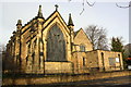
![Parish church [3]](https://s3.geograph.org.uk/geophotos/05/34/42/5344227_715ff066_120x120.jpg)
Parish church [3]
In addition to the church of St John itself, the wall, railings and gates of the churchyard are also listed, grade II, with details at: https://www.historicengland.org.uk/listing/the-list/list-entry/134495
Image: © Michael Dibb
Taken: 30 Mar 2017
0.01 miles
3
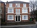
Gregory House
This lovely pair of semi-detached houses have been very well maintained. The combined property is now a care home.
Image: © Michael Dibb
Taken: 30 Mar 2017
0.02 miles
4
![Parish church [1]](https://s3.geograph.org.uk/geophotos/05/34/42/5344219_a66400b5_120x120.jpg)
Parish church [1]
In the style of Gothic Revival, the church of St John was erected in 1843 with additions in 1877 and 1922. Listed, grade II, with details at: https://www.historicengland.org.uk/listing/the-list/list-entry/1270647
Image: © Michael Dibb
Taken: 30 Mar 2017
0.03 miles
5
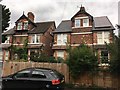
Nos. 1 -7 Yew Tree Avenue
Two Pairs of Semi-detached villas. Identified in D. Turner’s catalogue. “The drawings (from 1981) are annotated ‘Fothergill Watson, Architect, Clinton Street Nottingham’ but in a handwriting that does not appear to be Fothergill’s own”
Image: © David Lally
Taken: 3 Sep 2017
0.03 miles
6
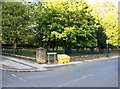
St John's Carrington, Mansfield Road
There is an Ordnance Survey benchmark Image on the wall in front of the church on the line of its left hand buttress
Image: © Luke Shaw
Taken: 8 Mar 2019
0.03 miles
7
![Parish church [2]](https://s0.geograph.org.uk/geophotos/05/34/42/5344220_baf32fe1_120x120.jpg)
Parish church [2]
In the style of Gothic Revival, the church of St John was erected in 1843 with additions in 1877 and 1922. Listed, grade II, with details at: https://www.historicengland.org.uk/listing/the-list/list-entry/1270647
Image: © Michael Dibb
Taken: 30 Mar 2017
0.04 miles
8
St John's Church graveyard at Church Drive / Loscoe Road junction
There is an Ordnance Survey benchmark Image on the corner wall pier left on the Church Drive name sign
Image: © Luke Shaw
Taken: 13 Sep 2019
0.04 miles
9
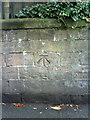
Benchmark on wall of Mansfield Road, outside St John's Carrington
Ordnance Survey cut mark benchmark which is described on the Bench Mark Database at http://www.bench-marks.org.uk/bm35141.
Image: © Roger Templeman
Taken: 10 Aug 2010
0.04 miles
10
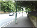
Mansfield Road at junction with Church Drive
View down Mansfield Road from pavement outside St John's Carrington.
Image: © Roger Templeman
Taken: 10 Aug 2010
0.04 miles