IMAGES TAKEN NEAR TO
New Street, NOTTINGHAM, NG5 2BH
Introduction
This page details the photographs taken nearby to New Street, NG5 2BH by members of the Geograph project.
The Geograph project started in 2005 with the aim of publishing, organising and preserving representative images for every square kilometre of Great Britain, Ireland and the Isle of Man.

There are currently over 7.5m images from over14,400 individuals and you can help contribute to the project by visiting https://www.geograph.org.uk
Image Map
Images are licensed for reuse under creativecommons.org/licenses/by-sa/2.0
Notes
- Clicking on the map will re-center to the selected point.
- The higher the marker number, the further away the image location is from the centre of the postcode.
Image Listing (144 Images Found)
Images are licensed for reuse under creativecommons.org/licenses/by-sa/2.0
Image
Details
Distance
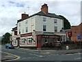
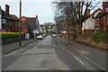
2
Carrington: Mansfield Road
The New Carrington Inn on the left and shops to the right.
Image: © John Sutton
Taken: 15 Jun 2014
0.02 miles
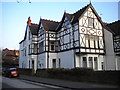
3
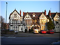
Southwell Lodge from Mansfield Road
Formerly the Woodville Hotel, these retrospectively conjoined houses were converted to bedsits in 2003. The porch visible above the van near the centre of the picture was I believe the main entrance when it was a hotel, but is no longer used.
Image: © Richard Vince
Taken: 12 Apr 2010
0.04 miles
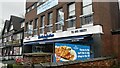
4
Ebers Hotel
This small hotel in Mansfield Road is undergoing some repair work. It is very evident that, despite appearance, the building is not timber framed.
Image: © Michael Dibb
Taken: 30 Mar 2017
0.04 miles
5
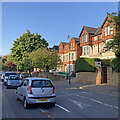
Ebers Road, Mapperley Park
Looking towards Mansfield Road from the junction with Zulla Road.
Mapperley Park is a large estate built at the end of the 19th century and the beginning of the 20th century in the grounds of Mapperley Hall. The houses are an eclectic mix of Victorian styles showing examples of large family villas, semi-detached houses and late Victorian terraces. Ebers Road is on the western side of the estate.
Image: © Kate Jewell
Taken: 3 Jan 2008
0.04 miles
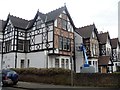
7
Southwell Lodge from Ebers Road
The northern section of Southwell Lodge (more of which is visible in Image). The rather haphazard shape of this part of the building appears to indicate that it has been extended more than once.
Image: © Richard Vince
Taken: 12 Apr 2010
0.05 miles
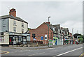
8
Carrington, Nottingham NG5
The main entrance of Carrington Primary School, Jenner Street with Hucknall Road (i.e. the A611) in the distance, with the entrance into the Lidl supermarket car park on the left.
Image: © David Hallam-Jones
Taken: 12 Oct 2014
0.05 miles
9
Carrington, Nottingham NG5
The main entrance to Carrington Primary School on Jenner Street. Acorn House, the new-ish (2013) care-home and dementia unit is seen on the Wesley Road/Oak Street corner site ahead.
Image: © David Hallam-Jones
Taken: 12 Oct 2014
0.05 miles
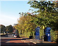
10
Zulla Road: red brick and horse chestnut spikes
Substantial houses in Mapperley Park, photographed on a bright May evening.
Image: © John Sutton
Taken: 20 May 2023
0.07 miles