IMAGES TAKEN NEAR TO
Staplehurst Drive, NOTTINGHAM, NG5 1NY
Introduction
This page details the photographs taken nearby to Staplehurst Drive, NG5 1NY by members of the Geograph project.
The Geograph project started in 2005 with the aim of publishing, organising and preserving representative images for every square kilometre of Great Britain, Ireland and the Isle of Man.

There are currently over 7.5m images from over14,400 individuals and you can help contribute to the project by visiting https://www.geograph.org.uk
Image Map
Images are licensed for reuse under creativecommons.org/licenses/by-sa/2.0
Notes
- Clicking on the map will re-center to the selected point.
- The higher the marker number, the further away the image location is from the centre of the postcode.
Image Listing (42 Images Found)
Images are licensed for reuse under creativecommons.org/licenses/by-sa/2.0
Image
Details
Distance
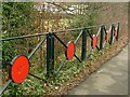
1
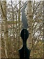
Hucknall Road Walkway marker ? rabbit
Alongside Hucknall Road at the southern end of the Walkway.
Image: © Alan Murray-Rust
Taken: 8 Feb 2022
0.09 miles
2
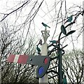
Signal sculpture with birds, Hucknall Road Walkway
Combining the main features of the walkway – former railway line, and nature reserve.
Image: © Alan Murray-Rust
Taken: 8 Feb 2022
0.09 miles
3
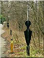
Hucknall Road Walkway markers
Alongside Hucknall Road at the southern end of the Walkway.
Image: © Alan Murray-Rust
Taken: 8 Feb 2022
0.09 miles
4
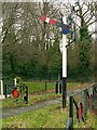
The southern entrance to Hucknall Road Walkway
The signal represents the fact that the walkway follows a former railway line.
Image: © Alan Murray-Rust
Taken: 8 Feb 2022
0.09 miles
5
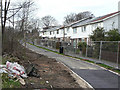
Foot- and cycleway improvement.
Part of the development of a linear walkway along the old GNR Leen Valley railway.
Image: © Alan Murray-Rust
Taken: 15 Mar 2009
0.10 miles
6
Roadside railings, Hucknall Road
Installed as part of the Hucknall Road Walkway which runs in the background. It has various wildlife and associated motifs.
Image: © Alan Murray-Rust
Taken: 8 Feb 2022
0.12 miles
7
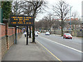
Electronic Road Sign
At this particular time motorists were being exhorted to use one of the park and Ride sites associated with the Nottingham Tram.
Image: © Alan Murray-Rust
Taken: 15 Mar 2009
0.13 miles
8
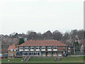
Nottingham High School Pavilion
On the School's playing fields alongside Valley Road
Image: © Alan Murray-Rust
Taken: 15 Mar 2009
0.14 miles
9
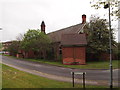
Nottingham - NG5 (City Hospital)
The rear of a building on the perimeter road near to Gate 1 currently being used by the Occupational Health Department. This is one of the last remaining pavilion wards used for patients with pulmonary tuberculosis when this was the Bagthorpe Isolation Hospital (later Heathfield Hospital). Two of the 'wings' of the pavilion design (pavilion being derived from the Latin for butterfly) can be seen on this end elevation.
Image: © David Hallam-Jones
Taken: 4 May 2012
0.14 miles
10
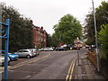
Nottingham - NG5 (City Hospital)
The Gate 1 entrance and exit to City Hospital on Hucknall Road is the one nearest to Arnold Road (B6004). This was the entrance to Bagthorpe Hospital (later called Heathfield Hospital). This isolation facility was opened on 15th July 1892 by the Mayor of Nottingham. Miss Dickinson, the hospital’s first Matron and Dr Wynne, the Assistant Medical Officer were in attendance. The red-brick building on the right housed its administrative offices, whereas the actual clinical buildings were further in, where the new maternity unit now stands.
Image: © David Hallam-Jones
Taken: 4 May 2012
0.14 miles