IMAGES TAKEN NEAR TO
Riber Crescent, NOTTINGHAM, NG5 1LP
Introduction
This page details the photographs taken nearby to Riber Crescent, NG5 1LP by members of the Geograph project.
The Geograph project started in 2005 with the aim of publishing, organising and preserving representative images for every square kilometre of Great Britain, Ireland and the Isle of Man.

There are currently over 7.5m images from over14,400 individuals and you can help contribute to the project by visiting https://www.geograph.org.uk
Image Map
Images are licensed for reuse under creativecommons.org/licenses/by-sa/2.0
Notes
- Clicking on the map will re-center to the selected point.
- The higher the marker number, the further away the image location is from the centre of the postcode.
Image Listing (31 Images Found)
Images are licensed for reuse under creativecommons.org/licenses/by-sa/2.0
Image
Details
Distance
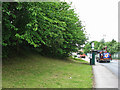
1
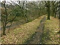
Alongside the Hucknall Road Walkway
The walkway is in the bottom of the railway cutting, which typically has been populated with sycamore trees. However, the top of the bank retains a line of mature oak trees which formed a windbreak alongside Hucknall Road prior to the construction of the railway in the late 19th century.
Image: © Alan Murray-Rust
Taken: 8 Feb 2022
0.06 miles
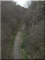
2

Hucknall Road Walkway
On the trackbed of the former Great Northern Railway's Leen Valley branch. The walkway also provides an important wildlife corridor.
Image: © Alan Murray-Rust
Taken: 8 Feb 2022
0.10 miles
3
Railway trail
Footpath on the alignment of the old GNR Leen Valley branch railway seen from Arnold Road bridge.
Image: © Alan Murray-Rust
Taken: 15 Mar 2009
0.10 miles
4
Arnold Road: where the Great Central was
The line of trees marks the former course of the Great Central main line from Nottingham Victoria to Sheffield and Manchester, which crossed Arnold Road on a bridge just to the right. This was a good spot for trainspotting, with traffic on the GC and also the GN Derby Friargate line. Derby-bound trains took the Bagthorpe West Curve, which crossed Arnold Road a little way down the hill to the left (see Image]); when the smoke of those from Derby was spotted away to the left, beyond the sidings where the depot behind these railings is, there was a frantic dash under the GC bridge to the right to see them emerge from the short "Rathole" tunnel which had brought them under the GN Back Line to Daybrook and Colwick and the GC - they then passed under Arnold Road on their way along the single-track Bagthorpe East Curve, whose route is echoed by the northern end of Fenton Road, which was built after the railway was closed and its cuttings and embankments filled or levelled, landscaped or built on.
Image: © John Sutton
Taken: 21 Jun 2011
0.12 miles
5
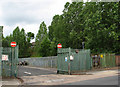
Nottingham - NG6
Arnold Road (B6004) is joined beyond the supermarket by Heathfield Road (named after of its association with Bagthorpe Isolation Hospital that later became Heathfield Hospital perhaps). The supermarket opened in 2011 in what was previously "The Heathfield" pub. Traffic travelling down this road ultimately reaches the David Lane tram stop.
Image: © David Hallam-Jones
Taken: 4 May 2012
0.13 miles
6
Arnold Road bus stop: where there was once a railway bridge
To Nottinghamians of my vintage, the interest of this picture may be in the grassy wooded slope on the left, which is all that remains of the Great Central Railway embankment. This was the site of a girder bridge which carried the Nottingham Victoria to Sheffield and Manchester main line, closed in 1968 and its course largely obliterated in the city and to the north.
This was a good spot for trainspotting, with traffic on the GC and also the GN Derby Friargate line. Derby-bound trains took the Bagthorpe West Curve, which crossed Arnold Road a little way down the hill (see Image]); when the smoke of those from Derby was spotted away to the right, beyond the sidings where a depot now is, there was a frantic dash under the GC bridge to see them emerge from the short "Rathole" tunnel which had brought them under the GN Back Line to Daybrook and Colwick and the GC (under the present Britannia Avenue, to the right) - they then passed under Arnold Road (just behind the camera) on their way to Bagthorpe Junction and Nottingham Victoria along the single-track Bagthorpe East Curve, whose route is echoed by the northern end of Fenton Road, which was built after the railway was closed and its cuttings and embankments filled or levelled, landscaped or built on. (Those post-War trainspotters were of course sustained by sherbet lemons and penny chews from Nellie Bisby's shop on Arnold Road.)
Image: © John Sutton
Taken: 21 Jun 2011
0.15 miles
7

Cycle trail on former railway beside the A611
Image: © JThomas
Taken: 17 Apr 2010
0.15 miles
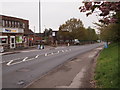
8
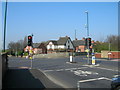
Junction of Arnold Road (B6004) and Hucknall Road (A611)
Image: © JThomas
Taken: 17 Apr 2010
0.15 miles
10

UK Green Traffic Light Signal
UK Green Traffic Light Signal at the busy Crossroads Junction on Hucknall Road, Nottingham
Image: © gary
Taken: 2 Feb 2016
0.16 miles