IMAGES TAKEN NEAR TO
Hucknall Road, NOTTINGHAM, NG5 1FJ
Introduction
This page details the photographs taken nearby to Hucknall Road, NG5 1FJ by members of the Geograph project.
The Geograph project started in 2005 with the aim of publishing, organising and preserving representative images for every square kilometre of Great Britain, Ireland and the Isle of Man.

There are currently over 7.5m images from over14,400 individuals and you can help contribute to the project by visiting https://www.geograph.org.uk
Image Map
Images are licensed for reuse under creativecommons.org/licenses/by-sa/2.0
Notes
- Clicking on the map will re-center to the selected point.
- The higher the marker number, the further away the image location is from the centre of the postcode.
Image Listing (80 Images Found)
Images are licensed for reuse under creativecommons.org/licenses/by-sa/2.0
Image
Details
Distance
1
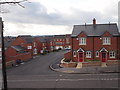
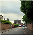
Nottingham - Ex Sara Lee/Courtaulds Factory Site
The new housing estate, referred to by Peveril Homes plc as "Burlington Place Sherwood" (a.k.a. Kelham Drive, NG5 1FJ) that has been built on the site of the old Sara Lee/Courtaulds textile-factory site. This photo was taken from the garden of the Tennyson Court maisonette block on the opposite side of Hucknall Rd (A611). The estate was completed in mid-late 2011.
Image: © David Hallam-Jones
Taken: 10 Mar 2012
0.03 miles
2
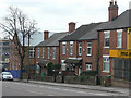
Housing on Hucknall Road
Late 19th century terraced housing makes a real contrast to the style looking up the hill Image
Image: © Alan Murray-Rust
Taken: 15 Mar 2009
0.03 miles
3

Kelham Court
New housing on a previous industrial site.
Image: © Alan Murray-Rust
Taken: 15 Mar 2009
0.04 miles
4
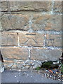
Benchmark on wall of Hucknall Road
Ordnance Survey cut mark benchmark described on the Bench Mark Database at http://www.bench-marks.org.uk/bm42701
Image: © Roger Templeman
Taken: 24 Apr 2012
0.05 miles
5
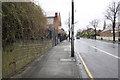
Hucknall Road (A611) opposite Leonard Avenue
There is an OS benchmark Image on the wall at the left hand side of the image
Image: © Roger Templeman
Taken: 9 Apr 2012
0.06 miles
6

Benchmark on wall on Hucknall Road
Ordnance Survey cut mark benchmark which is described on the Bench Mark Database at http://www.bench-marks.org.uk/bm35158.
Image: © Roger Templeman
Taken: 10 Aug 2010
0.06 miles
7
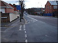
Bagthorpe NG5, Nottingham.
Hucknall Road (the A611) seen here from Compton Road. The bus is less than 100 yds away from Perry Road crossroads. H.M.Prison Nottingham, once known as Bagthorpe Gaol, is situated in Perry Road.
Image: © David Hallam-Jones
Taken: 13 Jun 2013
0.06 miles
8
Nottingham - Bagthorpe
A view of the A611 (Hucknall Rd) as it descends to cross the junction with Haydn Rd, before ascending the other side of the valley towards the city centre.
The factory on the right-hand side is currently occupied by "Rachel Ellen", a company manufacturing greetings cards. Immediately beyond it is a two storey office block that forms part of a local Severn Trent Water Authority depot. This depot occupies a large corner site at the Hucknall Rd/Haydn Rd junction. The Bagthorpe Water Works, reservoir and pumping station first developed this site in 1857.
Image: © David Hallam-Jones
Taken: 10 Mar 2012
0.07 miles
9
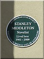
Plaque to Stanley Middleton
On right hand side of front of 42 Caledon Road. Celebrating the centenary of the birth of the author who was joint winner of the Booker Prize in 1974 with "Holiday".
Image: © El Loco
Taken: 7 Apr 2021
0.08 miles
10
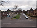
Nottingham - Bagthorpe neighbourhood
Glendon Road NG5. In the past this (much wider) neighbourhood was known as Bagthorpe. The race track layout of this road forms the entrance and exit to two branch roads at its far end.
Image: © David Hallam-Jones
Taken: 10 Mar 2012
0.08 miles