IMAGES TAKEN NEAR TO
Hucknall Road, NOTTINGHAM, NG5 1FE
Introduction
This page details the photographs taken nearby to Hucknall Road, NG5 1FE by members of the Geograph project.
The Geograph project started in 2005 with the aim of publishing, organising and preserving representative images for every square kilometre of Great Britain, Ireland and the Isle of Man.

There are currently over 7.5m images from over14,400 individuals and you can help contribute to the project by visiting https://www.geograph.org.uk
Image Map
Images are licensed for reuse under creativecommons.org/licenses/by-sa/2.0
Notes
- Clicking on the map will re-center to the selected point.
- The higher the marker number, the further away the image location is from the centre of the postcode.
Image Listing (75 Images Found)
Images are licensed for reuse under creativecommons.org/licenses/by-sa/2.0
Image
Details
Distance
1
Nottingham - Bagthorpe
View of the A611 (Hucknall Road) as it descends into the valley that is traversed by Haydn Road. It then ascends in the direction of the city centre. The area on the right-hand side of the picture is in the Berridge (local government) ward, whilst the area on the left lies within Sherwood ward.
Image: © David Hallam-Jones
Taken: 10 Mar 2012
0.03 miles
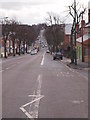
2
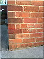
JaQues hair salon, Hucknall Road
There is an OS benchmark Image on the near corner of the building
Image: © Roger Templeman
Taken: 9 Apr 2012
0.04 miles
3
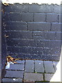
Benchmark on JaQues Hair & Beauty, Hucknall Road
Ordnance Survey 1962 cut mark benchmark described on the Bench Mark Database at http://www.bench-marks.org.uk/bm35161.
Image: © Roger Templeman
Taken: 10 Aug 2010
0.04 miles
4
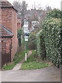
Nottingham - Bagthorpe Gardens (Allotments), NG5
A view of the footpath connecting Hucknall Rd (A611) and one of the entrances into Bagthorpe gardens. This allotment complex is apparently a vast area of garden plots that are owned by Nottingham City Council and rented out to tenants. An outer perimeter fence is in place and entry is via one of several padlocked gates. There is another entry into the allotments from a track off Haydn Rd. On National Heritage Day each visits and tours of the allotments are available to the general public.
Image: © David Hallam-Jones
Taken: 15 Mar 2012
0.05 miles
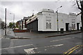
5
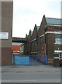
Former textile factory
Now largely converted to small industrial units.
Image: © Alan Murray-Rust
Taken: 15 Mar 2009
0.06 miles
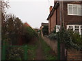
6
Nottingham - Bagthorpe Gardens (Allotments), NG5
A view of the inter-connecting path between the Council-owned Bagthorpe allotment 'complex' and Hucknall Road (A611) - visible in the distance. The house on the left-hand side is No.214 Aubrey Road, NG5
Image: © David Hallam-Jones
Taken: 15 Mar 2012
0.06 miles
7
Former textile works
On Haydn Road; now converted to industrial units.
Image: © Alan Murray-Rust
Taken: 15 Mar 2009
0.07 miles
8

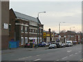
Hucknall Road
Looking south towards the neo-classical frontage of the former Thomas Forman printing works (1926), now the Indian Community Centre Association - http://www.theicca.co.uk/default.htm - and also containing flats and a branch of Tesco Express. The new housing built on the Forman site contrasts with the inter-wars and pre-1914 housing elsewhere in the area - see Image
Image: © John Sutton
Taken: 27 Apr 2011
0.08 miles
9
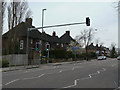
Housing on Hucknall Road
From the same viewpoint as Image but looking up the hill, there is a sudden change in the style of housing to a noticeably more modern type.
Image: © Alan Murray-Rust
Taken: 15 Mar 2009
0.08 miles
10
Benchmark on #25 Teesdale Road
Ordnance Survey cut mark benchmark described on the Bench Mark Database at http://www.bench-marks.org.uk/bm35162.
Image: © Roger Templeman
Taken: 10 Aug 2010
0.08 miles