IMAGES TAKEN NEAR TO
Erskine Road, NOTTINGHAM, NG5 1BP
Introduction
This page details the photographs taken nearby to Erskine Road, NG5 1BP by members of the Geograph project.
The Geograph project started in 2005 with the aim of publishing, organising and preserving representative images for every square kilometre of Great Britain, Ireland and the Isle of Man.

There are currently over 7.5m images from over14,400 individuals and you can help contribute to the project by visiting https://www.geograph.org.uk
Image Map
Images are licensed for reuse under creativecommons.org/licenses/by-sa/2.0
Notes
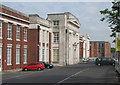
- Clicking on the map will re-center to the selected point.
- The higher the marker number, the further away the image location is from the centre of the postcode.
Image Listing (142 Images Found)
Images are licensed for reuse under creativecommons.org/licenses/by-sa/2.0
Image
Details
Distance
1
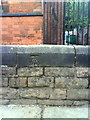
Benchmark on wall outside Claremont School
Ordnance Survey cut mark benchmark which is described on the Bench Mark Database at http://www.bench-marks.org.uk/bm35168.
Image: © Roger Templeman
Taken: 10 Aug 2010
0.04 miles
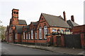
2
![Claremont School [1]](https://s3.geograph.org.uk/geophotos/05/34/64/5346467_7532f6d2_120x120.jpg)
Claremont School [1]
Now Claremont Primary School, this wonderful building was erected in 1884. In red brick with terracotta and ashlar dressings it is a testament to the builder's skill. The school and the boundary walls and gates is listed, grade II, with details at: https://www.historicengland.org.uk/listing/the-list/list-entry/1246788
Image: © Michael Dibb
Taken: 30 Mar 2017
0.04 miles
3
![Claremont School [2]](https://s0.geograph.org.uk/geophotos/05/34/64/5346472_ea250429_120x120.jpg)
Claremont School [2]
The tower and main entrance to the school. Now Claremont Primary School, this wonderful building was erected in 1884. In red brick with terracotta and ashlar dressings it is a testament to the builder's skill. The school and the boundary walls and gates is listed, grade II, with details at: https://www.historicengland.org.uk/listing/the-list/list-entry/1246788
Image: © Michael Dibb
Taken: 30 Mar 2017
0.04 miles
4
![Claremont School [3]](https://s3.geograph.org.uk/geophotos/05/34/64/5346475_ca8e5a49_120x120.jpg)
Claremont School [3]
Details of the main entrance with datestone. Now Claremont Primary School, this wonderful building was erected in 1884. In red brick with terracotta and ashlar dressings it is a testament to the builder's skill. The school and the boundary walls and gates is listed, grade II, with details at: https://www.historicengland.org.uk/listing/the-list/list-entry/1246788
Image: © Michael Dibb
Taken: 30 Mar 2017
0.04 miles
5
![Claremont School [4]](https://s1.geograph.org.uk/geophotos/05/34/64/5346477_7469a610_120x120.jpg)
Claremont School [4]
Seen here gleaming in the early evening sunlight, this wonderful building was erected in 1884. In red brick with terracotta and ashlar dressings it is a testament to the builder's skill. The school and the boundary walls and gates is listed, grade II, with details at: https://www.historicengland.org.uk/listing/the-list/list-entry/1246788
Image: © Michael Dibb
Taken: 30 Mar 2017
0.04 miles
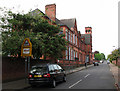
6
Claremont Primary and Nursery School, Claremont School
There is an OS benchmark Image on the stone wall left of the school entrance by the safety railing
Image: © Roger Templeman
Taken: 4 Nov 2017
0.04 miles
7
Claremont Primary and Nursery School
Typical of the schools built in Nottingham in the last quarter of the nineteenth century, after the Forster Education Act of 1870.
Image: © John Sutton
Taken: 27 Apr 2011
0.06 miles
8
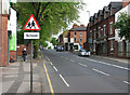
Hucknall Road, Carrington
Looking north towards the crest of the ridge. Claremont Road is on the left.
Image: © John Sutton
Taken: 27 Apr 2011
0.07 miles
9
The ICCA (formerly Thomas Forman & Sons Ltd)
The neo-classical frontage of the former Thomas Forman printing works (1926), now the Indian Community Centre Association - http://www.theicca.co.uk/default.htm - and also containing flats and a branch of Tesco Express. Thomas Forman (for whom my mother - and briefly my father - worked) specialised in the colour printing of such things as railway posters, calendars, labels and chequebooks. The factory closed in 1998 and much of the site behind this neo-classical frontage has been developed as housing in recent years - see Image
Image: © John Sutton
Taken: 27 Apr 2011
0.07 miles
10
Benchmark on wall of Hucknall Road opposite Bernard Street
Ordnance Survey cut mark benchmark which is described on the Bench Mark Database at http://www.bench-marks.org.uk/bm35159
Image: © Roger Templeman
Taken: 10 Aug 2010
0.07 miles