IMAGES TAKEN NEAR TO
Claremont Gardens, NOTTINGHAM, NG5 1BE
Introduction
This page details the photographs taken nearby to Claremont Gardens, NG5 1BE by members of the Geograph project.
The Geograph project started in 2005 with the aim of publishing, organising and preserving representative images for every square kilometre of Great Britain, Ireland and the Isle of Man.

There are currently over 7.5m images from over14,400 individuals and you can help contribute to the project by visiting https://www.geograph.org.uk
Image Map
Images are licensed for reuse under creativecommons.org/licenses/by-sa/2.0
Notes
- Clicking on the map will re-center to the selected point.
- The higher the marker number, the further away the image location is from the centre of the postcode.
Image Listing (159 Images Found)
Images are licensed for reuse under creativecommons.org/licenses/by-sa/2.0
Image
Details
Distance
1
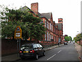
Claremont Primary and Nursery School
Typical of the schools built in Nottingham in the last quarter of the nineteenth century, after the Forster Education Act of 1870.
Image: © John Sutton
Taken: 27 Apr 2011
0.02 miles
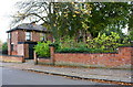
2
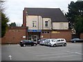
Social club
This uninspired building is the home of the Federation House Social Club. Seen from Claremont Road.
Image: © Michael Dibb
Taken: 30 Mar 2017
0.03 miles
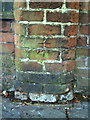
3
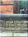
Benchmark on wall outside Claremont School
Ordnance Survey cut mark benchmark which is described on the Bench Mark Database at http://www.bench-marks.org.uk/bm35168.
Image: © Roger Templeman
Taken: 10 Aug 2010
0.04 miles
4
![Claremont School [1]](https://s3.geograph.org.uk/geophotos/05/34/64/5346467_7532f6d2_120x120.jpg)
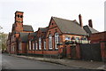
Claremont School [1]
Now Claremont Primary School, this wonderful building was erected in 1884. In red brick with terracotta and ashlar dressings it is a testament to the builder's skill. The school and the boundary walls and gates is listed, grade II, with details at: https://www.historicengland.org.uk/listing/the-list/list-entry/1246788
Image: © Michael Dibb
Taken: 30 Mar 2017
0.04 miles
5
![Claremont School [2]](https://s0.geograph.org.uk/geophotos/05/34/64/5346472_ea250429_120x120.jpg)
Claremont School [2]
The tower and main entrance to the school. Now Claremont Primary School, this wonderful building was erected in 1884. In red brick with terracotta and ashlar dressings it is a testament to the builder's skill. The school and the boundary walls and gates is listed, grade II, with details at: https://www.historicengland.org.uk/listing/the-list/list-entry/1246788
Image: © Michael Dibb
Taken: 30 Mar 2017
0.04 miles
6
![Claremont School [3]](https://s3.geograph.org.uk/geophotos/05/34/64/5346475_ca8e5a49_120x120.jpg)
Claremont School [3]
Details of the main entrance with datestone. Now Claremont Primary School, this wonderful building was erected in 1884. In red brick with terracotta and ashlar dressings it is a testament to the builder's skill. The school and the boundary walls and gates is listed, grade II, with details at: https://www.historicengland.org.uk/listing/the-list/list-entry/1246788
Image: © Michael Dibb
Taken: 30 Mar 2017
0.04 miles
7
![Claremont School [4]](https://s1.geograph.org.uk/geophotos/05/34/64/5346477_7469a610_120x120.jpg)
Claremont School [4]
Seen here gleaming in the early evening sunlight, this wonderful building was erected in 1884. In red brick with terracotta and ashlar dressings it is a testament to the builder's skill. The school and the boundary walls and gates is listed, grade II, with details at: https://www.historicengland.org.uk/listing/the-list/list-entry/1246788
Image: © Michael Dibb
Taken: 30 Mar 2017
0.04 miles
8
Claremont Primary and Nursery School, Claremont School
There is an OS benchmark Image on the stone wall left of the school entrance by the safety railing
Image: © Roger Templeman
Taken: 4 Nov 2017
0.04 miles
9
Nuffield House, #16 Claremont Road
There is an OS benchmark Image on the tall brick wall pier about 2m right of the entrance to this former day care centre.
Image: © Roger Templeman
Taken: 3 Nov 2017
0.06 miles
10
Benchmark on wall pier of Nuffield House Day Centre, Claremont Road
Ordnance Survey cut mark benchmark which is described on the Bench Mark Database at http://www.bench-marks.org.uk/bm35167.
Image: © Roger Templeman
Taken: 10 Aug 2010
0.06 miles