IMAGES TAKEN NEAR TO
Alexandra Street, NOTTINGHAM, NG5 1AY
Introduction
This page details the photographs taken nearby to Alexandra Street, NG5 1AY by members of the Geograph project.
The Geograph project started in 2005 with the aim of publishing, organising and preserving representative images for every square kilometre of Great Britain, Ireland and the Isle of Man.

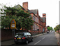
There are currently over 7.5m images from over14,400 individuals and you can help contribute to the project by visiting https://www.geograph.org.uk
Image Map
Images are licensed for reuse under creativecommons.org/licenses/by-sa/2.0
Notes
- Clicking on the map will re-center to the selected point.
- The higher the marker number, the further away the image location is from the centre of the postcode.
Image Listing (180 Images Found)
Images are licensed for reuse under creativecommons.org/licenses/by-sa/2.0
Image
Details
Distance
1
Damaged benchmark at #16 Alexander Road
The remains of a 1962 Ordnance Survey cut mark benchmark which is described on the Bench Mark Database at http://www.bench-marks.org.uk/bm35137.
Image: © Roger Templeman
Taken: 10 Aug 2010
0.01 miles
2
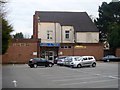
Social club
This uninspired building is the home of the Federation House Social Club. Seen from Claremont Road.
Image: © Michael Dibb
Taken: 30 Mar 2017
0.07 miles
3
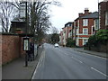
Bus stop and shelter on Sherwood Rise (B682)
Image: © JThomas
Taken: 27 Mar 2017
0.10 miles
4
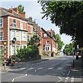
Sherwood Rise
Looking up the hill towards New Basford from near the corner of Alberta Terrace.
Image: © John Sutton
Taken: 6 Jul 2015
0.10 miles
5
Claremont Primary and Nursery School
Typical of the schools built in Nottingham in the last quarter of the nineteenth century, after the Forster Education Act of 1870.
Image: © John Sutton
Taken: 27 Apr 2011
0.10 miles
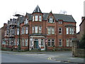
7
Nuffield House, #16 Claremont Road
There is an OS benchmark Image on the tall brick wall pier about 2m right of the entrance to this former day care centre.
Image: © Roger Templeman
Taken: 3 Nov 2017
0.10 miles
8
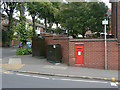
Post box NG7 20
A fine example of an uncommon A-size wall box from the late Victorian period. On Sherwood Rise at the junction of Hamilton Road.
Image: © Alan Murray-Rust
Taken: 27 Aug 2009
0.10 miles
9
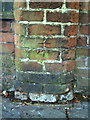
Benchmark on wall pier of Nuffield House Day Centre, Claremont Road
Ordnance Survey cut mark benchmark which is described on the Bench Mark Database at http://www.bench-marks.org.uk/bm35167.
Image: © Roger Templeman
Taken: 10 Aug 2010
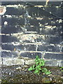
0.11 miles
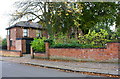
10
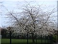
Hucknall Road blossom
In stark contrast to the ugly neighbour Image is this blossom.
Image: © Michael Dibb
Taken: 30 Mar 2017
0.11 miles