IMAGES TAKEN NEAR TO
Cocker Beck, NOTTINGHAM, NG4 4QP
Introduction
This page details the photographs taken nearby to Cocker Beck, NG4 4QP by members of the Geograph project.
The Geograph project started in 2005 with the aim of publishing, organising and preserving representative images for every square kilometre of Great Britain, Ireland and the Isle of Man.

There are currently over 7.5m images from over14,400 individuals and you can help contribute to the project by visiting https://www.geograph.org.uk
Image Map
Images are licensed for reuse under creativecommons.org/licenses/by-sa/2.0
Notes
- Clicking on the map will re-center to the selected point.
- The higher the marker number, the further away the image location is from the centre of the postcode.
Image Listing (104 Images Found)
Images are licensed for reuse under creativecommons.org/licenses/by-sa/2.0
Image
Details
Distance
1
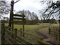
Bird watcher at Lambley Reed Pond
A spring fed pond and area of unimproved grassland, owned by Nottinghamshire Wildlife Trust
http://www.nottinghamshirewildlife.org.uk/nature-reserves/reed-pond/
Image: © Peter Barr
Taken: 9 Mar 2010
0.02 miles
2
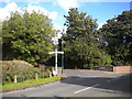
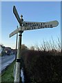
Bottom of Church Street, Lambley
Complete with finger post. Straight on for Lowdham, left and up the hill for Woodborough.
Image: © Richard Vince
Taken: 10 Oct 2014
0.04 miles
3
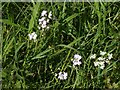
Lady's Smock (Cardamine pratensis) - Lambley Reed Pond
In Lambley Reed Pond nature reserve. See also http://www.geograph.org.uk/photo/6482037
Image: © Alan Murray-Rust
Taken: 20 May 2020
0.04 miles
4
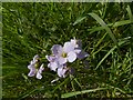
Lady's Smock (Cardamine pratensis)
In Lambley Reed Pond nature reserve. See also http://www.geograph.org.uk/photo/6482036
Image: © Alan Murray-Rust
Taken: 20 May 2020
0.04 miles
5
Direction Sign ? Signpost
Located on the northwest side of the T junction of Church Street and Main Street in Lambley parish. 4 arms and pawn finial. See also http://www.geograph.org.uk/photo/1014449.
Milestone Society National ID: NT_SK6345
Image: © R Grant
Taken: 4 Dec 2019
0.04 miles
6
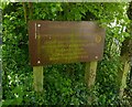
Footpath notice, Lambley
Encouraging the use of the extensive local network of public footpaths.
Image: © Alan Murray-Rust
Taken: 20 May 2020
0.04 miles
7
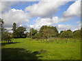
Lambley NG4, Notts.
A view across Lambley Reed Pond nature reserve towards Park Lane. This wetland reserve has been owned by the Nottinghamshire Wildlife Trust since 1993 when it was donated by Mr & Mrs Burks of Reed Pond House. The reserve includes an area of unimproved grassland of 11.2 hectares and a spring-fed pond covering 1/3 of a hectare. It is thought that the original pond provided fish for the adjacent vicarage table. The pond is known to be marked on the 1609 "Sherwood Forest Map". It was however, drained or filled in at one point. In 1974 Mr Burks was able to restore water to the site by excavating a trench on the south side, lining it and allowing it to back-fill.
Image: © David Hallam-Jones
Taken: 12 May 2013
0.05 miles
8

Cast iron signpost
Traditional cast iron fingerpost at the junction of Church Street and Main Street.
Image: © Alan Murray-Rust
Taken: 17 Oct 2008
0.05 miles
9
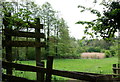
Nature reserve, Lambley
This small nature reserve at the east end of the village is based around a pond, hidden in the foliage in the distance, and is crossed by a public footpath that is fairly visible in this view.
Image: © Richard Vince
Taken: 10 Oct 2014
0.05 miles
10

Lambley Reed Pond
The Conservation Area report of Gedling Borough Council comments:
"The reserve is an area of pasture with a large stream-fed pond in the middle. The pond was originally a medieval stew or fish pond that was later filled in, before being re-opened in 1974. The pond and pasture combine to make an attractive natural space adjacent to the village."
The pasture is used for cattle grazing and the reserve is managed by the Notts Wildlife Trust.
Image: © Alan Murray-Rust
Taken: 17 Oct 2008
0.06 miles