IMAGES TAKEN NEAR TO
Catfoot Lane, NOTTINGHAM, NG4 4QL
Introduction
This page details the photographs taken nearby to Catfoot Lane, NG4 4QL by members of the Geograph project.
The Geograph project started in 2005 with the aim of publishing, organising and preserving representative images for every square kilometre of Great Britain, Ireland and the Isle of Man.

There are currently over 7.5m images from over14,400 individuals and you can help contribute to the project by visiting https://www.geograph.org.uk
Image Map
Images are licensed for reuse under creativecommons.org/licenses/by-sa/2.0
Notes
- Clicking on the map will re-center to the selected point.
- The higher the marker number, the further away the image location is from the centre of the postcode.
Image Listing (4 Images Found)
Images are licensed for reuse under creativecommons.org/licenses/by-sa/2.0
Image
Details
Distance
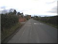
1
Catfoot Lane west of Lambley
The entrance visible on the right is that of the car park for Floralands garden centre.
Image: © Richard Vince
Taken: 10 Apr 2014
0.07 miles
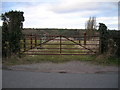
2
Public footpath to Lambley from Catfoot Lane
The footpath goes north along the edge of the field and then turns hard east to parallel Catfoot Lane to reach Lambley.
Image: © Richard Vince
Taken: 10 Apr 2014
0.09 miles