IMAGES TAKEN NEAR TO
Trinity Crescent, NOTTINGHAM, NG4 4PX
Introduction
This page details the photographs taken nearby to Trinity Crescent, NG4 4PX by members of the Geograph project.
The Geograph project started in 2005 with the aim of publishing, organising and preserving representative images for every square kilometre of Great Britain, Ireland and the Isle of Man.

There are currently over 7.5m images from over14,400 individuals and you can help contribute to the project by visiting https://www.geograph.org.uk
Image Map (124 Images)


Getting Data...Please wait
Leaflet Map data © OpenStreetMap
Images are licensed for reuse under creativecommons.org/licenses/by-sa/2.0
Notes
- Clicking on the map will re-center to the selected point.
- The higher the marker number, the further away the image location is from the centre of the postcode.
Image Listing (124 Images Found)
Images are licensed for reuse under creativecommons.org/licenses/by-sa/2.0
Image
Details
Distance
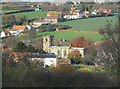
1

Lambley Village
Viewed from the mound on Round Hill. The village nestles in the bottom of the Cocker Beck valley where it splits into the two Lambley 'Dumbles'. The steep sided valley has been cut out of glacial deposits by the streams.
Image: © Alan Murray-Rust
Taken: 17 Oct 2008
0.03 miles
2
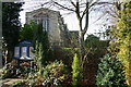
Lambley Parish Church
Lambley parish church on a bright January day
Image: © Nigel Stewart
Taken: 31 Jan 2009
0.03 miles
3
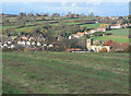
View over Lambley
Note the ridge and furrow cultivation pattern in the foreground.
Image: © Alan Murray-Rust
Taken: 14 Nov 2008
0.04 miles
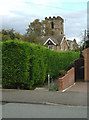
4

Footpath past Lambley Church
This is a public right of way.
Image: © Alan Murray-Rust
Taken: 17 Oct 2008
0.04 miles
5

Lambley Church
Pevsher describes this as :
"One of the few almost entirely Perp[endicular] churches in Notts, all of a piece and of felicitous proportions"
Image: © Alan Murray-Rust
Taken: 17 Oct 2008
0.05 miles
6
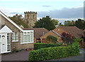
Orchard Rise estate
The junction of Steeles Way with Orchard Rise with Lambley Church in the background. A touch of suburbia in village with lots of historical character.
Image: © Alan Murray-Rust
Taken: 17 Oct 2008
0.05 miles
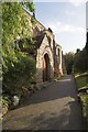
8
Footpath near Lambley Church
This is clearly an old right of way which has become modernised as a result of later housing development.
Image: © Alan Murray-Rust
Taken: 17 Oct 2008
0.05 miles
9
Lambley Church and Green Lane
A fine perpendicular-style church, seen to advantage from the ridge near Lodge Farm. behind can be seen the cottages on Green Lane. Most of these consist of short rows built at right angles to the road, to get the benrfit of sunlight. The narrow strip of land on which they are built was once the village green (in this case specifically a common grazing area) from which Green Lane gets its name.
Image: © Alan Murray-Rust
Taken: 14 Nov 2008
0.05 miles
10
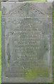
Slate gravestone
There are many fine slate gravestones in local churchyards from the early years of the 19th century. This one clearly tells of the unfortunate young mother who did not survive the complications of childbirth, and the infant daughter who survived her by a mere 4 weeks.
Image: © Alan Murray-Rust
Taken: 17 Oct 2008
0.05 miles