IMAGES TAKEN NEAR TO
Chapel Lane, NOTTINGHAM, NG4 4PT
Introduction
This page details the photographs taken nearby to Chapel Lane, NG4 4PT by members of the Geograph project.
The Geograph project started in 2005 with the aim of publishing, organising and preserving representative images for every square kilometre of Great Britain, Ireland and the Isle of Man.

There are currently over 7.5m images from over14,400 individuals and you can help contribute to the project by visiting https://www.geograph.org.uk
Image Map
Images are licensed for reuse under creativecommons.org/licenses/by-sa/2.0
Notes
- Clicking on the map will re-center to the selected point.
- The higher the marker number, the further away the image location is from the centre of the postcode.
Image Listing (119 Images Found)
Images are licensed for reuse under creativecommons.org/licenses/by-sa/2.0
Image
Details
Distance
1
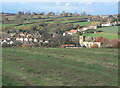
View over Lambley
Note the ridge and furrow cultivation pattern in the foreground.
Image: © Alan Murray-Rust
Taken: 14 Nov 2008
0.03 miles
2

Steeles Way
This takes its name form the owner of the orchard that it replaced.
Image: © Alan Murray-Rust
Taken: 17 Oct 2008
0.03 miles
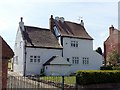
3
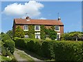
Mill House, Mill Lane, Lambley
Originally c.1820 with latter extensions, Listed Grade II.
The windmill would have been just off the picture to the left. It was demolished some time around 1910.
Image: © Alan Murray-Rust
Taken: 20 May 2020
0.04 miles
4
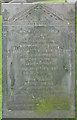
Slate gravestone
There are many fine slate gravestones in local churchyards from the early years of the 19th century. This one clearly tells of the unfortunate young mother who did not survive the complications of childbirth, and the infant daughter who survived her by a mere 4 weeks.
Image: © Alan Murray-Rust
Taken: 17 Oct 2008
0.05 miles
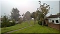
5

Footpath past Orchard Rise
It was clearly a requirement of the development of the little housing estate that this (Presumably pre-existing) path should be maintained with plenty of open space, as the estate continues on the west (right-hand) side for only a couple of houses.
Image: © Alan Murray-Rust
Taken: 17 Oct 2008
0.06 miles
6
Orchard Rise, Lambley
A residential cul de sac off Main Street.
Image: © Richard Vince
Taken: 10 Oct 2014
0.06 miles
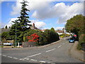
7
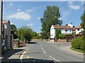
Main Street, Lambley
Looking west near Orchard Rise.
Image: © Alan Murray-Rust
Taken: 20 May 2020
0.07 miles
9
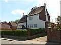
52 Main Street, Lambley
Originally two houses, early 17th and early 18th century, retaining some timber framing. Possibly the oldest domestic building in the village. Listed Grade II.
Image: © Alan Murray-Rust
Taken: 20 May 2020
0.07 miles
10
52 Main Street, Lambley
Originally two houses, early 17th and early 18th century, retaining some timber framing. Possibly the oldest domestic building in the village. Listed Grade II.
Image: © Alan Murray-Rust
Taken: 20 May 2020
0.07 miles