IMAGES TAKEN NEAR TO
Ross Lane, NOTTINGHAM, NG4 4PQ
Introduction
This page details the photographs taken nearby to Ross Lane, NG4 4PQ by members of the Geograph project.
The Geograph project started in 2005 with the aim of publishing, organising and preserving representative images for every square kilometre of Great Britain, Ireland and the Isle of Man.

There are currently over 7.5m images from over14,400 individuals and you can help contribute to the project by visiting https://www.geograph.org.uk
Image Map
Images are licensed for reuse under creativecommons.org/licenses/by-sa/2.0
Notes
- Clicking on the map will re-center to the selected point.
- The higher the marker number, the further away the image location is from the centre of the postcode.
Image Listing (104 Images Found)
Images are licensed for reuse under creativecommons.org/licenses/by-sa/2.0
Image
Details
Distance
1

Cocker Beck valley
The two Lambley 'Dumbles' come together at Lambley to form the Cocker Beck. The steep side valley is due to the rosion of glacial deposits by the streams which flow in the valleys.
Image: © Alan Murray-Rust
Taken: 17 Oct 2008
0.00 miles
2

The Robin Hood Inn
On Main Street. Part of the Conservation Area of Lambley.
Image: © Alan Murray-Rust
Taken: 17 Oct 2008
0.00 miles
3

The Robin Hood Inn from Orchard Rise
This view also shows (to the left of the pub) a typical feature of the historic part of the village - rows of cottages built end-on to the road, rather than alongside.
Image: © Alan Murray-Rust
Taken: 17 Oct 2008
0.01 miles
4
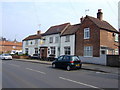
The Robin Hood and Little John, Lambley, Notts
Still splendidly adorned in Mansfield brewery colours.
Image: © al partington
Taken: 28 Mar 2007
0.01 miles
5

Bus to Nottingham
Passing the Robin Hood Inn at Lambley. The service is secured by funding from Nottinghamshire County Council.
Image: © Alan Murray-Rust
Taken: 17 Oct 2008
0.01 miles
6

Cottages on Main Street
A typical set of cottages in this village running at right angles to the main road.
Image: © Alan Murray-Rust
Taken: 17 Oct 2008
0.03 miles
7
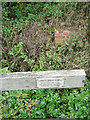
Not drinking water
The spring referred to had a reputation of having the sweetest water for a long way around, and was often sought in preference to that from a pump closer to home. The exact location of the spring is not obvious due to the amount of vegetation.
Image: © Alan Murray-Rust
Taken: 17 Oct 2008
0.03 miles
8

Cottages on Main Street
Typical for Lambley is the way these cottages are built as a row at right angles to the street.
Image: © Alan Murray-Rust
Taken: 17 Oct 2008
0.03 miles
9

Lambley Spring
The spring was right at the side of the stream which runs between the footpath and the hedge and reached by a bridge which has recently disappeared. It is described in the information board as having "[an] extremely pleasant taste, coolness, crystal clarity and reliability." It is of course now tested as being unfit to drink.
Image: © Alan Murray-Rust
Taken: 17 Oct 2008
0.03 miles
10

Cast iron signpost
Traditional cast iron fingerpost at the junction of Church Street and Main Street.
Image: © Alan Murray-Rust
Taken: 17 Oct 2008
0.04 miles