IMAGES TAKEN NEAR TO
Lambley Lane, NOTTINGHAM, NG4 4PA
Introduction
This page details the photographs taken nearby to Lambley Lane, NG4 4PA by members of the Geograph project.
The Geograph project started in 2005 with the aim of publishing, organising and preserving representative images for every square kilometre of Great Britain, Ireland and the Isle of Man.

There are currently over 7.5m images from over14,400 individuals and you can help contribute to the project by visiting https://www.geograph.org.uk
Image Map
Images are licensed for reuse under creativecommons.org/licenses/by-sa/2.0
Notes
- Clicking on the map will re-center to the selected point.
- The higher the marker number, the further away the image location is from the centre of the postcode.
Image Listing (95 Images Found)
Images are licensed for reuse under creativecommons.org/licenses/by-sa/2.0
Image
Details
Distance
1
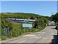
Gedling Access Road on Lambley Lane
Notice with the main construction compound beyond.
Image: © Alan Murray-Rust
Taken: 25 May 2020
0.01 miles
2
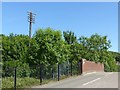
Telegraph pole alongside Lambley Lane
This is a rare survivor, from railway days. Clearly the wires were carried above the road rather than through the bridge, so a particularly tall pole was needed.
Image: © Alan Murray-Rust
Taken: 25 May 2020
0.02 miles
3
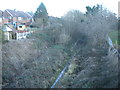
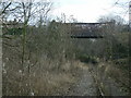
Railway trackbed, Gedling (2)
Maps generally still seem to mark this as a railway line, though here, where it passes under Lambley Lane, the track appears to have been lifted. This was the Great Northern Railway's "back line", which turned through 180 degrees around the edge of greater Nottingham to head eventually west into Derbyshire. After closure as a through route in the early 1960s, this section survived to provide rail access to Gedling Colliery (a short distance behind the photographer), which closed in 1991.
Image: © Richard Vince
Taken: 11 Feb 2014
0.02 miles
4
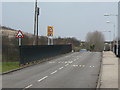
Lambley Lane railway bridge
The bridge does indeed have a severe hump, and the presence of the junction with Jessops Lane just on the far side makes all the road signs very pertinent.
Image: © Alan Murray-Rust
Taken: 1 Feb 2009
0.03 miles
5
Lambley Lane bridge
Looking towards Netherfield. When the Nottinghamshire coalfield was at its height, this line would have been busy with coal trains coming down to the marshalling yard at Colwick, and the line was double track. In later years only Gedling Colliery was served and the line was reduced to a single track which was essentially a long siding.
Image: © Alan Murray-Rust
Taken: 1 Feb 2009
0.03 miles
6
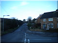
Lambley Lane, Gedling
Seen from the end of Jessops Lane, right on the edge of the greater Nottingham conurbation. On the left, the slag heaps of Gedling colliery (closed 1991) can just be seen in the distance.
Image: © Richard Vince
Taken: 11 Feb 2014
0.03 miles
7
The course of the former Great Northern Railway line
Seen from Lambley Lane Bridge.
Image: © Jonathan Thacker
Taken: 5 Jun 2018
0.03 miles
8
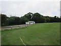
Cricket Pavilion, Lambley Lane Recreation Ground
Image: © Jonathan Thacker
Taken: 5 Jun 2018
0.04 miles
9
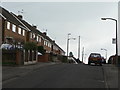
Jessops Lane
Post war housing to the east of the old great Northern railway line.
Image: © Alan Murray-Rust
Taken: 1 Feb 2009
0.05 miles
10
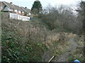
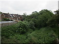
Railway cutting
After passing under Lambley Lane, the line runs below the backs of houses on Jessops Lane.
Image: © Alan Murray-Rust
Taken: 1 Feb 2009
0.06 miles