IMAGES TAKEN NEAR TO
Renshaw Drive, NOTTINGHAM, NG4 4LR
Introduction
This page details the photographs taken nearby to Renshaw Drive, NG4 4LR by members of the Geograph project.
The Geograph project started in 2005 with the aim of publishing, organising and preserving representative images for every square kilometre of Great Britain, Ireland and the Isle of Man.

There are currently over 7.5m images from over14,400 individuals and you can help contribute to the project by visiting https://www.geograph.org.uk
Image Map
Images are licensed for reuse under creativecommons.org/licenses/by-sa/2.0
Notes
- Clicking on the map will re-center to the selected point.
- The higher the marker number, the further away the image location is from the centre of the postcode.
Image Listing (137 Images Found)
Images are licensed for reuse under creativecommons.org/licenses/by-sa/2.0
Image
Details
Distance
1

Chase Farm, Gedling
New apartments, and construction compound.
Image: © Alan Murray-Rust
Taken: 24 Jan 2021
0.04 miles
2
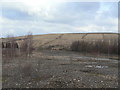
Gone without trace
The site of Gedling Colliery with the former spoil heap in the background.
Image: © Alan Murray-Rust
Taken: 1 Feb 2009
0.05 miles
3
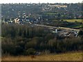
View from below the beacon
Early stages of new housing development alongside the old colliery approach road. When complete by 2022, this development will comprise over 1000 new homes. A new Gedling Bypass will run between the development and the Country Park through the old colliery site.
Image: © Alan Murray-Rust
Taken: 28 Dec 2017
0.06 miles
4
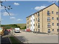
Apartment block, Waldrom Road, Gedling
Part of the Chase Farm housing development.
Image: © Alan Murray-Rust
Taken: 30 May 2020
0.06 miles
5
Former Gedling Colliery yard
This area was probably the coal storage area for the pit. Only a few straggly birches and some teasels are managing to win a living from this patch.
Image: © Alan Murray-Rust
Taken: 1 Feb 2009
0.06 miles
6
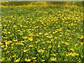
A blanket of buttercups
On Lambley Lane Recreation Ground.
Image: © Alan Murray-Rust
Taken: 25 May 2020
0.07 miles
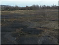
7
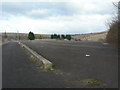
Gedling Colliery site
This expanse of tarmac appears to post-date the colliery and was probably connected with the use of the site for landfill.
Image: © Alan Murray-Rust
Taken: 1 Feb 2009
0.08 miles
8
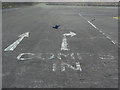
Comps in
Road markings at the old Gedling Colliery site. They appear to have been something to do with its subsequent use as a landfill site, but are meaning less to me.
Image: © Alan Murray-Rust
Taken: 1 Feb 2009
0.08 miles
9
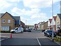
Renshaw Drive, Gedling
Part of Chase Farm housing development.
Image: © Alan Murray-Rust
Taken: 30 May 2020
0.08 miles
10
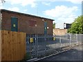
Substation on Waldrom Road, Gedling
A major local distribution point, the site doubtless chosen to be close to Gedling Colliery which would have been its major user. Now becoming surrounded by modern housing development.
Image: © Alan Murray-Rust
Taken: 30 May 2020
0.08 miles