IMAGES TAKEN NEAR TO
Horsley Lane, NOTTINGHAM, NG4 4LP
Introduction
This page details the photographs taken nearby to Horsley Lane, NG4 4LP by members of the Geograph project.
The Geograph project started in 2005 with the aim of publishing, organising and preserving representative images for every square kilometre of Great Britain, Ireland and the Isle of Man.

There are currently over 7.5m images from over14,400 individuals and you can help contribute to the project by visiting https://www.geograph.org.uk
Image Map
Images are licensed for reuse under creativecommons.org/licenses/by-sa/2.0
Notes
- Clicking on the map will re-center to the selected point.
- The higher the marker number, the further away the image location is from the centre of the postcode.
Image Listing (96 Images Found)
Images are licensed for reuse under creativecommons.org/licenses/by-sa/2.0
Image
Details
Distance
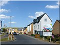
1
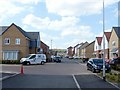
Renshaw Drive, Gedling
Part of Chase Farm housing development.
Image: © Alan Murray-Rust
Taken: 30 May 2020
0.03 miles
2
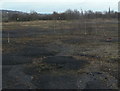
Former Gedling Colliery yard
This area was probably the coal storage area for the pit. Only a few straggly birches and some teasels are managing to win a living from this patch.
Image: © Alan Murray-Rust
Taken: 1 Feb 2009
0.03 miles
3
Chase Farm, Gedling
One year on from https://www.geograph.org.uk/photo/6014968 the houses are occupied and the landscaping more or less complete.
Image: © Alan Murray-Rust
Taken: 1 Jan 2020
0.04 miles
4
Chase Farm housing development
Over 1000 homes are being provided in this redevelopment of the former Gedling Colliery site. This is the earlier stage of the development alongside Arnold Lane (A6211).
Image: © Alan Murray-Rust
Taken: 1 Jan 2019
0.05 miles
5
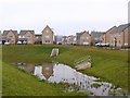
Chase Farm, Gedling
Balancing pond at the southern end of the site.
Image: © Alan Murray-Rust
Taken: 1 Jan 2020
0.09 miles
6
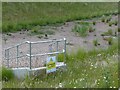
Danger deep water
This is a catchment pond http://www.geograph.org.uk/photo/6500007 for the Chase Farm housing development. Following dry April and May 2020, the notice is not exactly relevant.
Image: © Alan Murray-Rust
Taken: 30 May 2020
0.09 miles
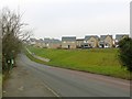
7
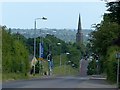
Arnold Lane, Gedling
Showing the hilly nature of this part of Gedling, looking towards the Trent Valley. The spire of Gedling Church is a prominent local landmark.
Image: © Alan Murray-Rust
Taken: 30 May 2020
0.10 miles
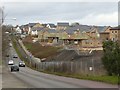
8
Chase Farm housing development
Gradually filling up the site of Gedling Colliery.
Image: © Alan Murray-Rust
Taken: 30 May 2020
0.10 miles
9
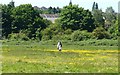
Walking through the buttercups
On Lambley Lane Recreation Ground.
Image: © Alan Murray-Rust
Taken: 25 May 2020
0.10 miles
10
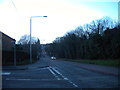
Arnold Lane, Gedling
Looking towards Arnold from the end of Besecar Avenue, Arnold Lane looks almost like a straight rollercoaster, epitomising the hilly nature of this part of Gedling.
Image: © Richard Vince
Taken: 11 Feb 2014
0.10 miles