IMAGES TAKEN NEAR TO
Haddon Close, NOTTINGHAM, NG4 4GT
Introduction
This page details the photographs taken nearby to Haddon Close, NG4 4GT by members of the Geograph project.
The Geograph project started in 2005 with the aim of publishing, organising and preserving representative images for every square kilometre of Great Britain, Ireland and the Isle of Man.

There are currently over 7.5m images from over14,400 individuals and you can help contribute to the project by visiting https://www.geograph.org.uk
Image Map
Images are licensed for reuse under creativecommons.org/licenses/by-sa/2.0
Notes
- Clicking on the map will re-center to the selected point.
- The higher the marker number, the further away the image location is from the centre of the postcode.
Image Listing (18 Images Found)
Images are licensed for reuse under creativecommons.org/licenses/by-sa/2.0
Image
Details
Distance
1
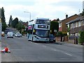
The return of service 25
From 31st May 2020, service 25 recommenced service following temporary withdrawal during the Covid-19 lockdown. At this stage it is very much a skeleton operation, running hourly compared with a normal 10 minute weekday headway on this section of the route. It is timed so that it combines with services 26 and 27 to provide a 15 minute headway between Carlton and City. A number of other routes in the city re-started at the same time.
Image: © Alan Murray-Rust
Taken: 31 May 2020
0.12 miles
2
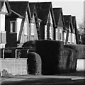
Inter-war black and white
Classic mock-tudor timbering of the period.
Image: © Alan Murray-Rust
Taken: 12 Jan 2021
0.16 miles
3
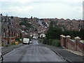
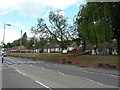
Baslow Avenue
Looking down to Westdale Lane. This road and its neighbours to the southeast are known locally as the 'Derbyshire Roads' because of their names.
Image: © Alan Murray-Rust
Taken: 1 Feb 2009
0.17 miles
4
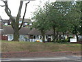
Cavendish Road Community Centre
Now run by Gedling Homes, the housing trust set up to run the former Gedling Borough Council housing stock. It is part of a development of around 20 bungalow-style properties for the elderly along Cavendish Road.
Image: © Alan Murray-Rust
Taken: 24 May 2011
0.18 miles
5
Elderly persons' bungalows, Cavendish Road
Originally Gedling Borough Council housing property, now run by Gedling Homes housing trust.
Image: © Alan Murray-Rust
Taken: 24 May 2011
0.18 miles
6
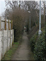
Footpath
This cuts through in a straight line from Thoresby Avenue to Besecar Avenue, and marks a distinct division between two periods of housing development. Looking at historic maps, it can be seen that this is in fact an old-established right of way, a continuation of the current Apple Tree Lane Image
Image: © Alan Murray-Rust
Taken: 1 Feb 2009
0.18 miles
7

Light, shade and texture
Anti-drive-through paving blocks. See http://www.geograph.org.uk/photo/6728808 for location.
Image: © Alan Murray-Rust
Taken: 12 Jan 2021
0.18 miles
8
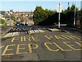
Fire path, keep clear
Anti-rat-run blocks on Belper Avenue which still allow for passage of large emergency vehicles.
Image: © Alan Murray-Rust
Taken: 12 Jan 2021
0.18 miles
10
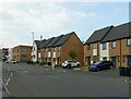
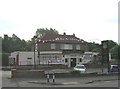
Housing on Cavendish Road
Developed around 2015 on the site of The Cavendish public house which had closed around 2010 https://www.geograph.org.uk/photo/2427869
Image: © Alan Murray-Rust
Taken: 27 May 2021
0.20 miles