IMAGES TAKEN NEAR TO
Westdale Lane, NOTTINGHAM, NG4 4FL
Introduction
This page details the photographs taken nearby to Westdale Lane, NG4 4FL by members of the Geograph project.
The Geograph project started in 2005 with the aim of publishing, organising and preserving representative images for every square kilometre of Great Britain, Ireland and the Isle of Man.

There are currently over 7.5m images from over14,400 individuals and you can help contribute to the project by visiting https://www.geograph.org.uk
Image Map
Images are licensed for reuse under creativecommons.org/licenses/by-sa/2.0
Notes
- Clicking on the map will re-center to the selected point.
- The higher the marker number, the further away the image location is from the centre of the postcode.
Image Listing (20 Images Found)
Images are licensed for reuse under creativecommons.org/licenses/by-sa/2.0
Image
Details
Distance
1
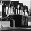
Inter-war black and white
Classic mock-tudor timbering of the period.
Image: © Alan Murray-Rust
Taken: 12 Jan 2021
0.04 miles
2
Over the edge
Freda Road, Gedling. It is signed as being a 20% gradient.
Image: © Alan Murray-Rust
Taken: 12 Jan 2021
0.12 miles
4
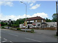
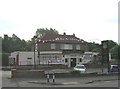
The Cavendish, Cavendish Road, Carlton
The Hand Car Wash sign conceals the 'To Let' sign on the front of this pub, which appears to be yet another suburban road-house-style-pub casualty.
Image: © Alan Murray-Rust
Taken: 24 May 2011
0.14 miles
5
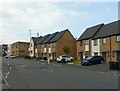
Housing on Cavendish Road
Developed around 2015 on the site of The Cavendish public house which had closed around 2010 https://www.geograph.org.uk/photo/2427869
Image: © Alan Murray-Rust
Taken: 27 May 2021
0.14 miles
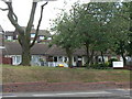
6
Elderly persons' bungalows, Cavendish Road
Originally Gedling Borough Council housing property, now run by Gedling Homes housing trust.
Image: © Alan Murray-Rust
Taken: 24 May 2011
0.17 miles
7
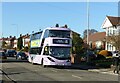
?We're good to go!?
Nottingham City Transport service 25 bus on Westdale Lane.
Image: © Alan Murray-Rust
Taken: 12 Jan 2021
0.17 miles
8
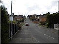
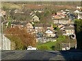
Freda Avenue, Gedling
The view up Freda Avenue from Shelford Road in Gedling. One of the steepest of the many steep roads in the area, Freda Avenue is particularly prone to becoming impassable in snowy or icy conditions.
Image: © Richard Vince
Taken: 4 Sep 2010
0.18 miles
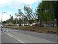
9
Cavendish Road Community Centre
Now run by Gedling Homes, the housing trust set up to run the former Gedling Borough Council housing stock. It is part of a development of around 20 bungalow-style properties for the elderly along Cavendish Road.
Image: © Alan Murray-Rust
Taken: 24 May 2011
0.19 miles
10
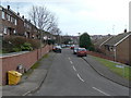
Chesterfield Avenue
Part of the large post-war development off Arnold Lane which was essentially a pit village for the neighbouring Gedling Colliery, although it abutted existing residential areas.
Image: © Alan Murray-Rust
Taken: 1 Feb 2009
0.21 miles