IMAGES TAKEN NEAR TO
Waterhouse Lane, NOTTINGHAM, NG4 4BP
Introduction
This page details the photographs taken nearby to Waterhouse Lane, NG4 4BP by members of the Geograph project.
The Geograph project started in 2005 with the aim of publishing, organising and preserving representative images for every square kilometre of Great Britain, Ireland and the Isle of Man.

There are currently over 7.5m images from over14,400 individuals and you can help contribute to the project by visiting https://www.geograph.org.uk
Image Map
Images are licensed for reuse under creativecommons.org/licenses/by-sa/2.0
Notes
- Clicking on the map will re-center to the selected point.
- The higher the marker number, the further away the image location is from the centre of the postcode.
Image Listing (43 Images Found)
Images are licensed for reuse under creativecommons.org/licenses/by-sa/2.0
Image
Details
Distance
1
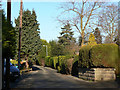
Waterhouse Lane
This is a traditional agricultural lane which has been subsequently developed for housing.
Image: © Alan Murray-Rust
Taken: 18 Jan 2009
0.02 miles
2

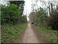
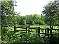
The end of Waterhouse Lane
This is part of a right of way through to Lambley, which has retained its alignment through more recent housing development, continuing in a more-or-less straight line past the left hand side of the distant woodland.
Image: © Alan Murray-Rust
Taken: 18 Jan 2009
0.04 miles
3
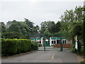
Willow Lane Primary School
A CLASP building.
Image: © Jonathan Thacker
Taken: 5 Jun 2018
0.10 miles
5
Gedling House Meadows – 1
Looking from the western end of Gedling House Wood
Image: © Alan Murray-Rust
Taken: 21 May 2023
0.12 miles
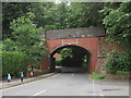
6
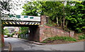
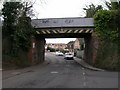
Gedling NG4, Notts.
The Main Road/Shearing Hill section of the A6211 is reached almost immediately on the other side of this former railway bridge (Bridge Ref: DEX/13). This road is Wood Lane, with Waterhouse Lane joining it from the right. The road behind the photographer terminates in the Yew Tree Lane/Gedling Wood Farm area.
Image: © David Hallam-Jones
Taken: 12 May 2013
0.13 miles
7
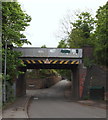
Wood Lane railway bridge
Part of the Great Northern Railway's long way round from Nottingham to Derby, its main purpose was to bring coal from the Notts and Derbys coalfield to its marshalling yard at Colwick. Mooted as a possible extension to the Nottingham tram network.
Image: © Alan Murray-Rust
Taken: 15 Jan 2020
0.13 miles
8
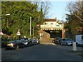
Gedling NG4, Notts.
The view of the former railway bridge (Bridge Ref: DEX/13) as seen from the A6211 (the Main Road/Shearing Hill section). This road is Wood Lane, with Waterhouse Lane branching off it to the left. The road ahead terminates near Yew Tree Lane where there is a track leading to Gedling Wood Farm.
Image: © David Hallam-Jones
Taken: 12 May 2013
0.13 miles
9
Willow Lane bridge
Bridge DEX-14 This carried the Derbyshire Extension line of the Great Northern Railway over Willow Lane.
Image: © Jonathan Thacker
Taken: 5 Jun 2018
0.13 miles