IMAGES TAKEN NEAR TO
Bleasdale Close, NOTTINGHAM, NG4 4BA
Introduction
This page details the photographs taken nearby to Bleasdale Close, NG4 4BA by members of the Geograph project.
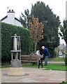
The Geograph project started in 2005 with the aim of publishing, organising and preserving representative images for every square kilometre of Great Britain, Ireland and the Isle of Man.

There are currently over 7.5m images from over14,400 individuals and you can help contribute to the project by visiting https://www.geograph.org.uk
Image Map
Images are licensed for reuse under creativecommons.org/licenses/by-sa/2.0
Notes
- Clicking on the map will re-center to the selected point.
- The higher the marker number, the further away the image location is from the centre of the postcode.
Image Listing (106 Images Found)
Images are licensed for reuse under creativecommons.org/licenses/by-sa/2.0
Image
Details
Distance
1
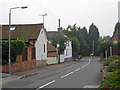
Gedling: Willow Lane
Some of the older houses in a village on the eastern edge of Nottingham.
Image: © John Sutton
Taken: 25 Sep 2013
0.03 miles
2
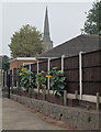
Gedling: spire and sunflowers
But no sunshine on a damp and misty September morning. For more about Gedling's celebrated spire, see Image
Image: © John Sutton
Taken: 25 Sep 2013
0.05 miles
3
First Gedling Scout and Guide Group
The spire of All Hallows church in the background.
Image: © Jonathan Thacker
Taken: 5 Jun 2018
0.05 miles
4
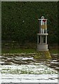
Gedling Miner's Lamp
A 5 foot high representation of a miner's safety lamp, erected in 2010 as a memorial to the 128 miners who lost their lives at nearby Gedling Colliery during its working life.
Image: © Alan Murray-Rust
Taken: 9 Feb 2021
0.06 miles
5
Gedling: tending the flowers at the miners' memorial
The memorial, in the form of a Davy Lamp, was created in 2010. It is dedicated to the 128 miners who lost their lives at Gedling Colliery and to all those who worked there from its sinking in 1899 until closure in 1991.
Image: © John Sutton
Taken: 25 Sep 2013
0.07 miles
6
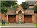
Lady Carnarvon's Fountain, Gedling
Erected in 1874 to form the village water supply. Water was piped from a local well. It was in use until the 1920s when mains water became available.
Image: © Alan Murray-Rust
Taken: 1 Jan 2020
0.07 miles
7
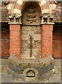
Lady Carnarvon's Fountain, Gedling ? detail
Erected in 1874 to form the village water supply. Water was piped from a local well. It was in use until the 1920s when mains water became available.
Close up view. Originally there was a pipe and tap for human use, the large basin provided for horses and cattle, and the small basin at the foot was for dogs.
Image: © Alan Murray-Rust
Taken: 1 Jan 2020
0.07 miles
8
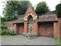
Victorian water fountain and trough
Main Road, Gedling.
Image: © Jonathan Thacker
Taken: 5 Jun 2018
0.07 miles
9
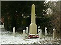
Gedling War Memorial
Erected as recently as 1979. To an extent, the Memorial Hall https://www.geograph.org.uk/photo/3678748 had served as the local memorial up to that point.
Image: © Alan Murray-Rust
Taken: 9 Feb 2021
0.07 miles
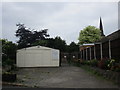
10
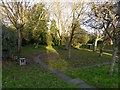
Willow Garden, Main Road, Gedling
A small public open space, designed and named by children from the Willow Farm Primary School.
Image: © Alan Murray-Rust
Taken: 15 Jan 2020
0.07 miles