IMAGES TAKEN NEAR TO
Sapele Close, NOTTINGHAM, NG4 4AP
Introduction
This page details the photographs taken nearby to Sapele Close, NG4 4AP by members of the Geograph project.
The Geograph project started in 2005 with the aim of publishing, organising and preserving representative images for every square kilometre of Great Britain, Ireland and the Isle of Man.

There are currently over 7.5m images from over14,400 individuals and you can help contribute to the project by visiting https://www.geograph.org.uk
Image Map
Images are licensed for reuse under creativecommons.org/licenses/by-sa/2.0
Notes
- Clicking on the map will re-center to the selected point.
- The higher the marker number, the further away the image location is from the centre of the postcode.
Image Listing (41 Images Found)
Images are licensed for reuse under creativecommons.org/licenses/by-sa/2.0
Image
Details
Distance
1

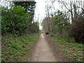
The end of Waterhouse Lane
This is part of a right of way through to Lambley, which has retained its alignment through more recent housing development, continuing in a more-or-less straight line past the left hand side of the distant woodland.
Image: © Alan Murray-Rust
Taken: 18 Jan 2009
0.07 miles
2
Footpath to Lambley
This is part of a right of way through to Lambley, which has retained its alignment through more recent housing development, continuing in a more-or-less straight line past the left hand side of the distant woodland.
Image: © Alan Murray-Rust
Taken: 18 Jan 2009
0.07 miles
3

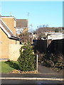
Yew Tree Lane
Housing development from the 1960s onwards.
Image: © Alan Murray-Rust
Taken: 18 Jan 2009
0.08 miles
4
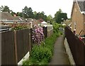
Footpath off Yew Tree Lane
The footpath is an old right of way, retained on its original alignment when the estate was developed.
Image: © Alan Murray-Rust
Taken: 25 May 2021
0.09 miles
5
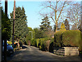
Waterhouse Lane
This is a traditional agricultural lane which has been subsequently developed for housing.
Image: © Alan Murray-Rust
Taken: 18 Jan 2009
0.09 miles
6
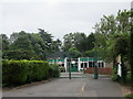
Willow Lane Primary School
A CLASP building.
Image: © Jonathan Thacker
Taken: 5 Jun 2018
0.09 miles
7
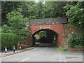
Willow Lane bridge
Bridge DEX-14 This carried the Derbyshire Extension line of the Great Northern Railway over Willow Lane.
Image: © Jonathan Thacker
Taken: 5 Jun 2018
0.13 miles
8
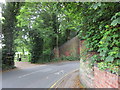
Approaching Willow Lane bridge
An entrance to Willow Park on the left.
Image: © Jonathan Thacker
Taken: 5 Jun 2018
0.14 miles
9
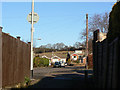
Footpath to Lambley
This is part of a right of way through to Lambley, which has retained its alignment through more recent housing development. Here it follows a short section of Yew Tree Lane, then Almond Walk before passing into the countryside to the left of the far house with the twin gables.
Image: © Alan Murray-Rust
Taken: 18 Jan 2009
0.14 miles