IMAGES TAKEN NEAR TO
Darley Avenue, NOTTINGHAM, NG4 3PA
Introduction
This page details the photographs taken nearby to Darley Avenue, NG4 3PA by members of the Geograph project.
The Geograph project started in 2005 with the aim of publishing, organising and preserving representative images for every square kilometre of Great Britain, Ireland and the Isle of Man.

There are currently over 7.5m images from over14,400 individuals and you can help contribute to the project by visiting https://www.geograph.org.uk
Image Map
Images are licensed for reuse under creativecommons.org/licenses/by-sa/2.0
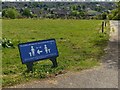
Notes
- Clicking on the map will re-center to the selected point.
- The higher the marker number, the further away the image location is from the centre of the postcode.
Image Listing (88 Images Found)
Images are licensed for reuse under creativecommons.org/licenses/by-sa/2.0
Image
Details
Distance
1
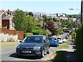
Darley Avenue, Gedling
One of the many steep roads in the area, looking across to St Michael's Avenue flats.
Image: © Alan Murray-Rust
Taken: 25 May 2020
0.01 miles
2
Ramsdale Road
Where my grandfather lived in the 1930s and 40s.
Image: © Mick Garratt
Taken: 5 Jan 2008
0.05 miles
3
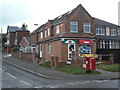
Darley Avenue Post Office
Local Post Office on Westdale Lane which has clearly expanded in recent years. Surprisingly for a wholly residential area it is not part of even a small group of shops. The pillar box is a GR model.
Image: © Alan Murray-Rust
Taken: 1 Feb 2009
0.05 miles
4
Oxford Street, Gedling
Not as impressive as it's London namesake!
Image: © Alan Murray-Rust
Taken: 30 May 2020
0.08 miles
5
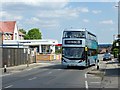
The return of service 25
From 31st May 2020, service 25 recommenced service following temporary withdrawal during the Covid-19 lockdown. At this stage it is very much a skeleton operation, running hourly compared with a normal 10 minute weekday headway on this section of the route. It is timed so that it combines with services 26 and 27 to provide a 15 minute headway between Carlton and City. A number of other routes in the city re-started at the same time.
Image: © Alan Murray-Rust
Taken: 31 May 2020
0.08 miles
6
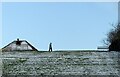
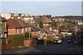
On the skyline
Cavendish Road Recreation ground after a light snowfall.
Image: © Alan Murray-Rust
Taken: 9 Feb 2021
0.10 miles
7
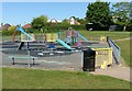
Recreation ground off Cavendish Road
Children's play area, closed due to Covid-19
Image: © Alan Murray-Rust
Taken: 25 May 2020
0.10 miles
8
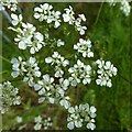
Carlton Cemetery Flowers ? Cow Parsley (Anthriscus sylvestris)
See also http://www.geograph.org.uk/photo/6478521
One of a series of pictures depicting wild flowers in Carlton Cemetery. The management of the as yet undeveloped section of the cemetery allows a number of traditional meadow flowers to flourish.
A slideshow of these flowers can be seen here http://www.geograph.org.uk/search.php?i=114777222
Image: © Alan Murray-Rust
Taken: 16 May 2020
0.10 miles
9
Carlton Cemetery ? Covid-19 sign
Standard social distancing sign. The cemetery is a valuable resource for local exercise during the lockdown.
Image: © Alan Murray-Rust
Taken: 16 May 2020
0.10 miles
10
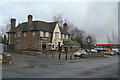
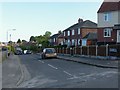
Westdale Tavern
Tween-wars roadhouse-style pub on Westdale Lane.
Image: © Alan Murray-Rust
Taken: 1 Feb 2009
0.10 miles