IMAGES TAKEN NEAR TO
Imperial Avenue, NOTTINGHAM, NG4 3NE
Introduction
This page details the photographs taken nearby to Imperial Avenue, NG4 3NE by members of the Geograph project.
The Geograph project started in 2005 with the aim of publishing, organising and preserving representative images for every square kilometre of Great Britain, Ireland and the Isle of Man.

There are currently over 7.5m images from over14,400 individuals and you can help contribute to the project by visiting https://www.geograph.org.uk
Image Map
Images are licensed for reuse under creativecommons.org/licenses/by-sa/2.0
Notes
- Clicking on the map will re-center to the selected point.
- The higher the marker number, the further away the image location is from the centre of the postcode.
Image Listing (45 Images Found)
Images are licensed for reuse under creativecommons.org/licenses/by-sa/2.0
Image
Details
Distance
1
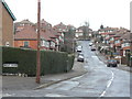
Cantley Avenue
Suburban development off Westdale Lane; this road is a cul-de-sac.
Image: © Alan Murray-Rust
Taken: 1 Feb 2009
0.05 miles
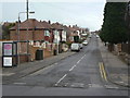
2
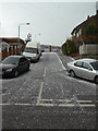
Radford Crescent
There appear to be just a couple of houses actually with an address on this street - and it's unusually straight for a crescent!
Image: © Alan Murray-Rust
Taken: 1 Feb 2009
0.09 miles
3
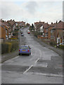
Roslyn Avenue
Suburban development off Westdale Lane. There is a tendency for this road to have its name misspelt, but it does have only one 's'.
Image: © Alan Murray-Rust
Taken: 1 Feb 2009
0.09 miles
4
St Michael's Avenue housing
Mid 20th century terraced housing, dating from the late 1960s, in a distinctive style of the period. Looking up from Adbolton Avenue
Image: © Alan Murray-Rust
Taken: 25 May 2020
0.09 miles
5
Adbolton Avenue
Tween-wars suburbia off Westdale Lane. It leads up to post-war developments.
Image: © Alan Murray-Rust
Taken: 1 Feb 2009
0.09 miles
6
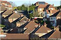
Carlton roofscape ? 4
Roslyn Drive, from Belper Avenue.
Image: © Alan Murray-Rust
Taken: 12 Jan 2021
0.10 miles
7
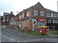
Darley Avenue Post Office
Local Post Office on Westdale Lane which has clearly expanded in recent years. Surprisingly for a wholly residential area it is not part of even a small group of shops. The pillar box is a GR model.
Image: © Alan Murray-Rust
Taken: 1 Feb 2009
0.11 miles
8
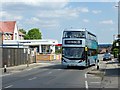
The return of service 25
From 31st May 2020, service 25 recommenced service following temporary withdrawal during the Covid-19 lockdown. At this stage it is very much a skeleton operation, running hourly compared with a normal 10 minute weekday headway on this section of the route. It is timed so that it combines with services 26 and 27 to provide a 15 minute headway between Carlton and City. A number of other routes in the city re-started at the same time.
Image: © Alan Murray-Rust
Taken: 31 May 2020
0.12 miles
9
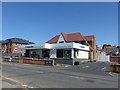
The Cooperative Food, Westdale Lane East
Local supermarket, Formerly the Westdale Tavern pub.
Image: © Alan Murray-Rust
Taken: 25 May 2020
0.12 miles
10
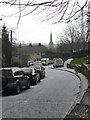
Phoenix Avenue
An astonishing contrast to Image taken just 3 minutes earlier.
Image: © Alan Murray-Rust
Taken: 1 Feb 2009
0.13 miles