IMAGES TAKEN NEAR TO
First Avenue, NOTTINGHAM, NG4 3JY
Introduction
This page details the photographs taken nearby to First Avenue, NG4 3JY by members of the Geograph project.
The Geograph project started in 2005 with the aim of publishing, organising and preserving representative images for every square kilometre of Great Britain, Ireland and the Isle of Man.

There are currently over 7.5m images from over14,400 individuals and you can help contribute to the project by visiting https://www.geograph.org.uk
Image Map
Images are licensed for reuse under creativecommons.org/licenses/by-sa/2.0
Notes
- Clicking on the map will re-center to the selected point.
- The higher the marker number, the further away the image location is from the centre of the postcode.
Image Listing (36 Images Found)
Images are licensed for reuse under creativecommons.org/licenses/by-sa/2.0
Image
Details
Distance
1
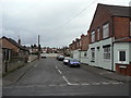
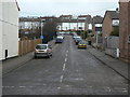
First Avenue
This is the only one of the three numbered Avenues off Priory Road which has houses from the early years of the 20th century.
Image: © Alan Murray-Rust
Taken: 1 Feb 2009
0.02 miles
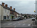
2
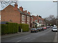
Priory Road
Looking northeast from Westdale Lane. The first three pairs of houses are dated 1901, 1902, 1902 respectively to give accurate dating of the development.
Image: © Alan Murray-Rust
Taken: 1 Feb 2009
0.03 miles
3
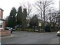
Priory Junior School
On Priory Road at the junction of Second Avenue.
Image: © Alan Murray-Rust
Taken: 1 Feb 2009
0.05 miles
4
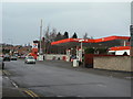
Filling Station
This one has not yet suffered the indignity of become a car-wash, but has changed hands recently; it was previously a BP station.
Image: © Alan Murray-Rust
Taken: 1 Feb 2009
0.08 miles
5
Westdale Lane
Looking north west from Priory Road. Note the traditional zebra crossing still in use. Westdale Lane is an old established road between Gedling and Mapperley that was developed with residential side roads from the 1920s onwards.
Image: © Alan Murray-Rust
Taken: 1 Feb 2009
0.09 miles
6
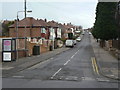
Adbolton Avenue
Tween-wars suburbia off Westdale Lane. It leads up to post-war developments.
Image: © Alan Murray-Rust
Taken: 1 Feb 2009
0.11 miles
7
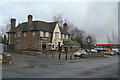
Westdale Tavern
Tween-wars roadhouse-style pub on Westdale Lane.
Image: © Alan Murray-Rust
Taken: 1 Feb 2009
0.11 miles
8
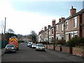
Priory Road
Development from just after the turn of the 20th Century. The next row of houses behind this set was not built until the 60s or 70s.
Image: © Alan Murray-Rust
Taken: 1 Feb 2009
0.11 miles
9
Third Avenue
Houses from the 60s/70s, although the road itself appears to day from the time the main street (Priory Road) that it branches off.
Image: © Alan Murray-Rust
Taken: 1 Feb 2009
0.11 miles
10
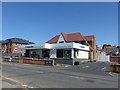
The Cooperative Food, Westdale Lane East
Local supermarket, Formerly the Westdale Tavern pub.
Image: © Alan Murray-Rust
Taken: 25 May 2020
0.11 miles