IMAGES TAKEN NEAR TO
Main Road, NOTTINGHAM, NG4 3HN
Introduction
This page details the photographs taken nearby to Main Road, NG4 3HN by members of the Geograph project.
The Geograph project started in 2005 with the aim of publishing, organising and preserving representative images for every square kilometre of Great Britain, Ireland and the Isle of Man.

There are currently over 7.5m images from over14,400 individuals and you can help contribute to the project by visiting https://www.geograph.org.uk
Image Map (Loading...)


Getting Data...Please wait
Leaflet Map data © OpenStreetMap
Images are licensed for reuse under creativecommons.org/licenses/by-sa/2.0
Notes
- Clicking on the map will re-center to the selected point.
- The higher the marker number, the further away the image location is from the centre of the postcode.
Image Listing (86 Images Found)
Images are licensed for reuse under creativecommons.org/licenses/by-sa/2.0
Image
Details
Distance
1
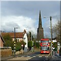
Red bus on Main Road, Gedling
Nottingham City Transport's route 44 provides a frequent service to the City Centre via Netherfield. In the background is the fine 13th century tower and spire of All Hallows Church, Listed Grade I. The deliberate entasis applied to the spire is a notable feature, quite unusual for the period.
Image: © Alan Murray-Rust
Taken: 9 Feb 2021
0.06 miles
2
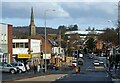
Gedling Road
A small local shopping centre with a variety of shops. The fine 13th century spire of All Hallows Church is a prominent local landmark.
Image: © Alan Murray-Rust
Taken: 9 Feb 2021
0.12 miles
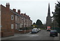
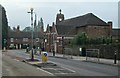
3
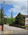
Church view from Church View
A picture taken from the Church View bus stop on Main Road.
Image: © John Sutton
Taken: 3 Jun 2015
0.13 miles
4
Gedling: Carnarvon Grove
The village expanded hugely after the building of the Great Northern Railway "Back Line" and the sinking of Gedling Colliery.
Image: © John Sutton
Taken: 3 Jun 2015
0.14 miles
5
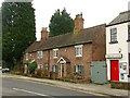
Ivy Cottages, Main Road, Gedling
Dating from around 1800, they are among the oldest surviving buildings in Gedling.
Image: © Alan Murray-Rust
Taken: 1 Jan 2020
0.15 miles
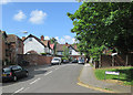
6
Priory Road
Looking north east with Gedling church in the background.
Image: © Alan Murray-Rust
Taken: 1 Feb 2009
0.15 miles
7
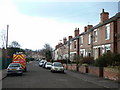
Priory Road
Development from just after the turn of the 20th Century. The next row of houses behind this set was not built until the 60s or 70s.
Image: © Alan Murray-Rust
Taken: 1 Feb 2009
0.15 miles
8
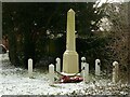
Gedling War Memorial
Erected as recently as 1979. To an extent, the Memorial Hall https://www.geograph.org.uk/photo/3678748 had served as the local memorial up to that point.
Image: © Alan Murray-Rust
Taken: 9 Feb 2021
0.15 miles
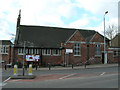
10
Gedling Memorial Hall
The hall, on the corner of Main Road and Arnold Lane, was given in memory of the dead of The Great War by Lt Col W H Blackburn. The foundation stone was laid by The Duke of Portland on 26 July 1924. The photograph was taken on a gloomy September morning.
Image: © John Sutton
Taken: 25 Sep 2013
0.16 miles