IMAGES TAKEN NEAR TO
Shearing Hill, NOTTINGHAM, NG4 3HA
Introduction
This page details the photographs taken nearby to Shearing Hill, NG4 3HA by members of the Geograph project.
The Geograph project started in 2005 with the aim of publishing, organising and preserving representative images for every square kilometre of Great Britain, Ireland and the Isle of Man.

There are currently over 7.5m images from over14,400 individuals and you can help contribute to the project by visiting https://www.geograph.org.uk
Image Map
Images are licensed for reuse under creativecommons.org/licenses/by-sa/2.0
Notes
- Clicking on the map will re-center to the selected point.
- The higher the marker number, the further away the image location is from the centre of the postcode.
Image Listing (48 Images Found)
Images are licensed for reuse under creativecommons.org/licenses/by-sa/2.0
Image
Details
Distance
1
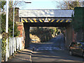
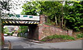
Wood Lane bridge
This carried the former Great Northern Railway Derbyshire Extension, running from Colwick via the north of Nottingham and Ilkeston to reach Derby by a very roundabout route. The residual passenger service disappeared in the wake of Beeching, but the line remained to serve Gedling Colliery until around 1990. It was later used for a limited amount of colliery waste removal, and the track remains in situ. The formation has been tentatively earmarked for extensions to the Nottingham tram system, as substantial housing development is planned for the former colliery site.
Image: © Alan Murray-Rust
Taken: 18 Jan 2009
0.04 miles
2
The old Gedling Station
View from the railway side. The buildings have been converted for business use.
Image: © Alan Murray-Rust
Taken: 25 May 2021
0.04 miles
3
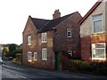
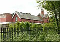
24 Shearing Hill, Gedling
The roadside elevation. The wing is a 19th century addition to the original 18th century farmhouse http://www.geograph.org.uk/photo/6369214 .
Image: © Alan Murray-Rust
Taken: 15 Jan 2020
0.04 miles
4
24 Shearing Hill, Gedling
Early 18th century farmhouse with later additions, Listed Grade II.
Image: © Alan Murray-Rust
Taken: 15 Jan 2020
0.04 miles
5
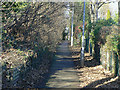
Footpath to Wood Lane
This footpath squeezes between the former railway embankment and Coronation Walk.
Image: © Alan Murray-Rust
Taken: 18 Jan 2009
0.05 miles
6
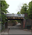
Gedling NG4, Notts.
The view of the former railway bridge (Bridge Ref: DEX/13) as seen from the A6211 (the Main Road/Shearing Hill section). This road is Wood Lane, with Waterhouse Lane branching off it to the left. The road ahead terminates near Yew Tree Lane where there is a track leading to Gedling Wood Farm.
Image: © David Hallam-Jones
Taken: 12 May 2013
0.05 miles
7
Wood Lane railway bridge
Part of the Great Northern Railway's long way round from Nottingham to Derby, its main purpose was to bring coal from the Notts and Derbys coalfield to its marshalling yard at Colwick. Mooted as a possible extension to the Nottingham tram network.
Image: © Alan Murray-Rust
Taken: 15 Jan 2020
0.05 miles
8
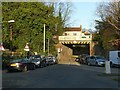
Gedling NG4, Notts.
The Main Road/Shearing Hill section of the A6211 is reached almost immediately on the other side of this former railway bridge (Bridge Ref: DEX/13). This road is Wood Lane, with Waterhouse Lane joining it from the right. The road behind the photographer terminates in the Yew Tree Lane/Gedling Wood Farm area.
Image: © David Hallam-Jones
Taken: 12 May 2013
0.06 miles
9
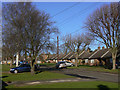
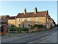
Coronation Walk
The name indicates that this small estate was developed in the early 1950s. This end of the estate, probably built to house elderly people, was a later addition.
Image: © Alan Murray-Rust
Taken: 18 Jan 2009
0.07 miles
10
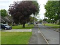
The top of Coronation Walk
A development of sheltered accommodation. A quiet cul-de-sac, but not too well sited for public transport or shopping access.
Image: © Alan Murray-Rust
Taken: 25 May 2021
0.08 miles