IMAGES TAKEN NEAR TO
St. Austins Drive, NOTTINGHAM, NG4 3EY
Introduction
This page details the photographs taken nearby to St. Austins Drive, NG4 3EY by members of the Geograph project.
The Geograph project started in 2005 with the aim of publishing, organising and preserving representative images for every square kilometre of Great Britain, Ireland and the Isle of Man.

There are currently over 7.5m images from over14,400 individuals and you can help contribute to the project by visiting https://www.geograph.org.uk
Image Map (17 Images)

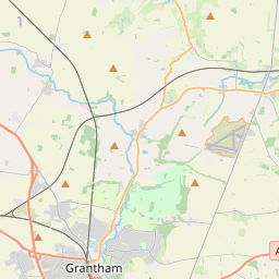

Leaflet Map data © OpenStreetMap
Images are licensed for reuse under creativecommons.org/licenses/by-sa/2.0
Notes
- Clicking on the map will re-center to the selected point.
- The higher the marker number, the further away the image location is from the centre of the postcode.
Image Listing (17 Images Found)
Images are licensed for reuse under creativecommons.org/licenses/by-sa/2.0
Image
Details
Distance
1
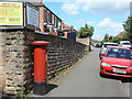
Gedling Road postbox NG4 443
GVIR pillar box on Gedling Road near Redland Grove.
Image: © Alan Murray-Rust
Taken: 24 May 2011
0.13 miles
2
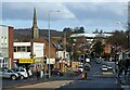
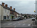
Gedling Road
A small local shopping centre with a variety of shops. The fine 13th century spire of All Hallows Church is a prominent local landmark.
Image: © Alan Murray-Rust
Taken: 9 Feb 2021
0.15 miles
3

Bench mark, Burton Road
See http://www.geograph.org.uk/photo/5024119 for location.
The local sandstone is prone to weathering, but this mark survives in good condition.
Image: © Alan Murray-Rust
Taken: 4 Jul 2016
0.16 miles
4
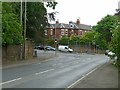
Burton Road/Gedling Road junction
There is a bench mark http://www.geograph.org.uk/photo/5024118 on the pier in the wall at the extreme left of the picture.
Image: © Alan Murray-Rust
Taken: 4 Jul 2016
0.16 miles
5
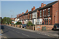
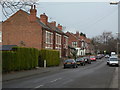
Burton Road, Carlton
Victorian small semi-detached villas. Most of these pairs still retain hand painted wooden name boards for each pair.
Image: © Alan Murray-Rust
Taken: 8 May 2008
0.19 miles
6
Westdale Lane
Looking north west from Priory Road. Note the traditional zebra crossing still in use. Westdale Lane is an old established road between Gedling and Mapperley that was developed with residential side roads from the 1920s onwards.
Image: © Alan Murray-Rust
Taken: 1 Feb 2009
0.20 miles
7
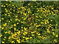
Carlton Cemetery Flowers ? Common Buttercup (Ranunculus acris)
One of a series of pictures depicting wild flowers in Carlton Cemetery. The management of the as yet undeveloped section of the cemetery allows a number of traditional meadow flowers to flourish.
A slideshow of these flowers can be seen here http://www.geograph.org.uk/search.php?i=114777222
Image: © Alan Murray-Rust
Taken: 16 May 2020
0.21 miles
8
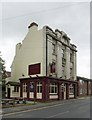
The Old Volunteer
Public House with an unusually fine terracotta facade for an outer-suburban location.
Image: © Alan Murray-Rust
Taken: 1 Jul 2012
0.21 miles
9
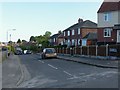
Priory Road
Looking northeast from Westdale Lane. The first three pairs of houses are dated 1901, 1902, 1902 respectively to give accurate dating of the development.
Image: © Alan Murray-Rust
Taken: 1 Feb 2009
0.21 miles
10
Oxford Street, Gedling
Not as impressive as it's London namesake!
Image: © Alan Murray-Rust
Taken: 30 May 2020
0.22 miles