IMAGES TAKEN NEAR TO
Burton Road, NOTTINGHAM, NG4 3DT
Introduction
This page details the photographs taken nearby to Burton Road, NG4 3DT by members of the Geograph project.
The Geograph project started in 2005 with the aim of publishing, organising and preserving representative images for every square kilometre of Great Britain, Ireland and the Isle of Man.

There are currently over 7.5m images from over14,400 individuals and you can help contribute to the project by visiting https://www.geograph.org.uk
Image Map
Images are licensed for reuse under creativecommons.org/licenses/by-sa/2.0
Notes
- Clicking on the map will re-center to the selected point.
- The higher the marker number, the further away the image location is from the centre of the postcode.
Image Listing (54 Images Found)
Images are licensed for reuse under creativecommons.org/licenses/by-sa/2.0
Image
Details
Distance
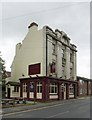
2
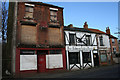
The Blacks Head, Burton Road
This pub is now called The Beacon Hill.
Image: © Bryn Holmes
Taken: 22 Mar 2019
0.03 miles
4
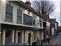
The Black's Head, Carlton
Many pubs with this name do have portrayed a negro's head, but this one has sported a horse's head for as long as I have lived in the area.
Image: © Alan Murray-Rust
Taken: 8 May 2008
0.03 miles
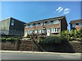
5
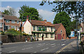
The Old Volunteer
Public House with an unusually fine terracotta facade for an outer-suburban location.
Image: © Alan Murray-Rust
Taken: 1 Jul 2012
0.04 miles
7
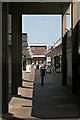
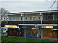
Carlton Square shopping precinct
Despite the attractions of the nearby superstore, this small precinct still supports a good variety of retail outlets.
Image: © Alan Murray-Rust
Taken: 8 May 2008
0.04 miles
8
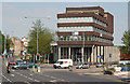
Carlton Council Offices
These were the Carlton Urban District Council (UDC) offices and Council Chamber (top floor rear) before the merger under the 1974 Local Government reorganisation with Arnold UDC to form Gedling Borough Council. The Council decided to concentrate resources and this building eventually became redundant. It is now owned by a private company which lets the offices commercially. The local Council outlet is now a small counter in this building Image
Image: © Alan Murray-Rust
Taken: 8 May 2008
0.06 miles
9
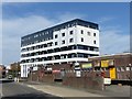
dbh house, Carlton Square
This is the former council offices building for Carlton Urban District Council, built around 1970. Made redundant following the merger with Arnold U D C to become Gedling Borough, it was first converted to rented office accommodation. In 2018 it reopened in its third guise having been converted into 1, 2 and 3 bedroom apartments, including an additional floor.
Image: © Alan Murray-Rust
Taken: 5 Apr 2020
0.06 miles
10
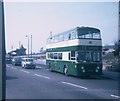
Bus at the Carlton Terminus
Taken in May 1969, this photo shows 515 (PTO 515G) a Leyland Atlantean with Northern Counties 76-seater bodywork in Cavendish Road, Carlton about to leave on route 72 to Wollaton Park via Nottingham City Centre. It was operated by Nottingham City Transport and has a blank illuminated advertisement panel below the upper deck windows. These panels were adopted by several UK bus operators in the 1960s, but with limited success from advertisers. This section of route from Carlton (Post Office Square) to Wollaton Park used to be operated by trolleybuses until the 30th September 1965, the route number then being 39. A few redundant trolleybus traction poles can be seen with the lamp standard to the left of the photo, but these would now have long ago been taken out. Cavendish Road in Carlton is now covered by Nottingham Buses Lilac Route 27 from Nottingham City Centre.
Image: © David Hillas
Taken: 3 May 1969
0.11 miles