IMAGES TAKEN NEAR TO
Eastmoor Drive, NOTTINGHAM, NG4 3BD
Introduction
This page details the photographs taken nearby to Eastmoor Drive, NG4 3BD by members of the Geograph project.
The Geograph project started in 2005 with the aim of publishing, organising and preserving representative images for every square kilometre of Great Britain, Ireland and the Isle of Man.

There are currently over 7.5m images from over14,400 individuals and you can help contribute to the project by visiting https://www.geograph.org.uk
Image Map
Images are licensed for reuse under creativecommons.org/licenses/by-sa/2.0
Notes
- Clicking on the map will re-center to the selected point.
- The higher the marker number, the further away the image location is from the centre of the postcode.
Image Listing (38 Images Found)
Images are licensed for reuse under creativecommons.org/licenses/by-sa/2.0
Image
Details
Distance
1
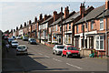
Willow Road
This road marks virtually the end of Victorian development; further east (right) the housing is very different in character, being tween wars housing development.
Image: © Alan Murray-Rust
Taken: 8 May 2008
0.02 miles
2
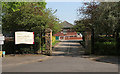
Conway Street Recreation Ground
The entrance on Conway Road
Image: © Alan Murray-Rust
Taken: 8 May 2008
0.11 miles
3
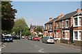
Conway Street
A typical suburban street of mixed age - this is the older end with Victorian semi-detached small villas.
Image: © Alan Murray-Rust
Taken: 8 May 2008
0.13 miles
4
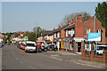
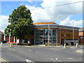
Shops on Burton Road
The mix is very much the standard modern set - chippy, computer repairs, hairdresser, closed Post Office, newsagent, takeaway and estate agent. However, the filling station does have a small supermarket attached.
Image: © Alan Murray-Rust
Taken: 8 May 2008
0.13 miles
5
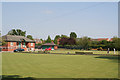
Conway Street Recreation Ground
A council-owned facility with well maintained bowling greens and tennis courts
Image: © Alan Murray-Rust
Taken: 8 May 2008
0.14 miles
6
Carlton Fire Station
Carlton Fire Station, Manor Road, Carlton, Nottingham
Image: © Kevin Hale
Taken: 29 Apr 2007
0.14 miles
7
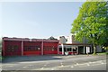
Carlton Fire Station
The new fire station opened officially in January 2011 to replace http://www.geograph.org.uk/photo/418380 . It was immediately in turmoil as the current spending cuts envisaged the loss of one of the two appliances stationed here, together with its retained status.
Image: © Alan Murray-Rust
Taken: 24 May 2011
0.15 miles
8
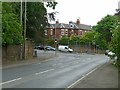
Burton Road/Gedling Road junction
There is a bench mark http://www.geograph.org.uk/photo/5024118 on the pier in the wall at the extreme left of the picture.
Image: © Alan Murray-Rust
Taken: 4 Jul 2016
0.15 miles
9
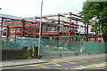
Carlton Fire Station
A brand new and improved version is taking shape on the old site. this is what the old one looked like http://www.geograph.org.uk/photo/418380
Image: © Alan Murray-Rust
Taken: 21 May 2010
0.16 miles
10
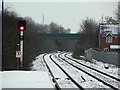
Looking east from carlton Station
On the Nottingham to Lincoln line. The station was formerly called Carlton and Netherfield and is in Netherfield rather than Carlton. The renaming distinguishes it from Netherfield Station, formerly Netherfield and Colwick.
Image: © Alan Murray-Rust
Taken: 2 Feb 2009
0.16 miles