IMAGES TAKEN NEAR TO
Braemar Drive, NOTTINGHAM, NG4 2RB
Introduction
This page details the photographs taken nearby to Braemar Drive, NG4 2RB by members of the Geograph project.
The Geograph project started in 2005 with the aim of publishing, organising and preserving representative images for every square kilometre of Great Britain, Ireland and the Isle of Man.

There are currently over 7.5m images from over14,400 individuals and you can help contribute to the project by visiting https://www.geograph.org.uk
Image Map
Images are licensed for reuse under creativecommons.org/licenses/by-sa/2.0
Notes
- Clicking on the map will re-center to the selected point.
- The higher the marker number, the further away the image location is from the centre of the postcode.
Image Listing (33 Images Found)
Images are licensed for reuse under creativecommons.org/licenses/by-sa/2.0
Image
Details
Distance
1
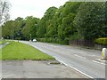
A612, Burton Rd, Carlton
Recreating this 'First' for the square http://www.geograph.org.uk/photo/35705
Image: © Alan Murray-Rust
Taken: 25 May 2021
0.09 miles
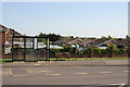
2
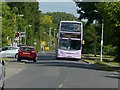
Service 26 bus on Stoke Lane, Gedling
The service is being diverted via Stoke Lane during the construction of the new junction for the Gedling Access Road at the end of Burton Road.
Image: © Alan Murray-Rust
Taken: 1 Jun 2020
0.11 miles
3
Coronation Walk, Gedling
Judging by the architecture, the coronation in question is likely to have been that of Elizabeth II.
Image: © Richard Vince
Taken: 29 Nov 2014
0.11 miles
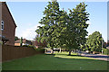
5
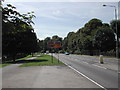
Don't use the bus!
The housing estate beyond the brick wall has been planned as if public transport does not exist. For the houses visible nearest the wall, a walk of the best part of 400 metres is needed to reach the bus stop as there is no gap in the wall.
Image: © Alan Murray-Rust
Taken: 8 May 2008
0.13 miles
6
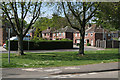
Coronation Walk
Typical early post war semi-detached housing development. The name gives the clue to the date.
Image: © Alan Murray-Rust
Taken: 8 May 2008
0.13 miles
7
Gedling, Coronation Walk and Burton Road, after Francis Frith
Taken to show how Francis Frith's view from c.1960 http://www.francisfrith.com/search/england/nottinghamshire/gedling/photos/gedling_G311009.htm looks today. An additional pair of semis have been built on what was open space to the left, and the garden wall and the trees have pretty well obscured the houses visible in Frith's picture.
Image: © Alan Murray-Rust
Taken: 19 Jun 2008
0.13 miles
8
The Holly and the Ivy
The nearer block of four houses is called Holly Villa, the pair beyond is Ivy Villa.
Image: © Alan Murray-Rust
Taken: 8 May 2008
0.14 miles
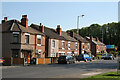
9
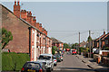
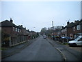
Florence Road
This terrace of houses was very much an outsider when built, being beyond the railway, but development caught up as can be seen by the variety of later housing styles.
Image: © Alan Murray-Rust
Taken: 8 May 2008
0.15 miles
10
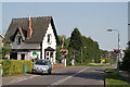
Stoke Lane level crossing
Seen from the north. It is interesting that railway companies considered it appropriate to build dwelling houses for employees doing what was not considered a particularly high grade job.
Image: © Alan Murray-Rust
Taken: 8 May 2008
0.15 miles