IMAGES TAKEN NEAR TO
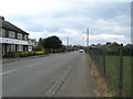
Emerys Road, NOTTINGHAM, NG4 2QQ
Introduction
This page details the photographs taken nearby to Emerys Road, NG4 2QQ by members of the Geograph project.
The Geograph project started in 2005 with the aim of publishing, organising and preserving representative images for every square kilometre of Great Britain, Ireland and the Isle of Man.

There are currently over 7.5m images from over14,400 individuals and you can help contribute to the project by visiting https://www.geograph.org.uk
Image Map
Images are licensed for reuse under creativecommons.org/licenses/by-sa/2.0
Notes
- Clicking on the map will re-center to the selected point.
- The higher the marker number, the further away the image location is from the centre of the postcode.
Image Listing (36 Images Found)
Images are licensed for reuse under creativecommons.org/licenses/by-sa/2.0
Image
Details
Distance
2
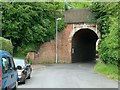
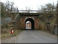
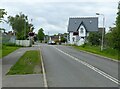
Railway bridge, Chandos Street
As built, the bridge simply catered for a farm track, and was never enlarged when Chandos Street and later Emerys Road were created. It still has no footway, and from this side approaching traffic has no real view through.
There is a bench mark http://www.geograph.org.uk/photo/5024106 on the pier at the end of the left hand abutment.
Image: © Alan Murray-Rust
Taken: 4 Jul 2016
0.12 miles
3
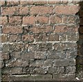
Bench mark, railway bridge, Chandos Street
See http://www.geograph.org.uk/photo/5024104 for location.
Image: © Alan Murray-Rust
Taken: 4 Jul 2016
0.12 miles
4
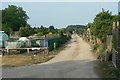
Stoke Lane allotments
Seen from the footpath which alongside the western edge.
Image: © Alan Murray-Rust
Taken: 24 May 2010
0.13 miles
7
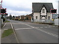
Level Crossing on Stoke Lane
The railway is the Nottingham to Newark line
Image: © Tom Courtney
Taken: 9 Aug 2005
0.14 miles
8
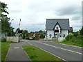
Stoke Lane level crossing
The former crossing-keeper's cottage is one of a number of buildings designed by local architect T C Hine for the opening of the Midland Railway's line between Nottingham and Lincoln in 1846. In a Victorian Tudor style, it has been clearly recently refurbished, very smartly.
Image: © Alan Murray-Rust
Taken: 4 Jul 2016
0.14 miles
9
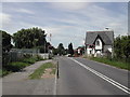
Level Crossing on Stoke Lane
Recreating this 'First' for the square https://www.geograph.org.uk/photo/35704
Image: © Alan Murray-Rust
Taken: 25 May 2021
0.14 miles
10
Shade and shape ? 1
Skatepark in Jubilee Park recreation ground.
Image: © Alan Murray-Rust
Taken: 17 Dec 2020
0.14 miles