IMAGES TAKEN NEAR TO
Swan Meadow, NOTTINGHAM, NG4 2ET
Introduction
This page details the photographs taken nearby to Swan Meadow, NG4 2ET by members of the Geograph project.
The Geograph project started in 2005 with the aim of publishing, organising and preserving representative images for every square kilometre of Great Britain, Ireland and the Isle of Man.

There are currently over 7.5m images from over14,400 individuals and you can help contribute to the project by visiting https://www.geograph.org.uk
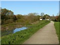
Image Map
Images are licensed for reuse under creativecommons.org/licenses/by-sa/2.0
Notes
- Clicking on the map will re-center to the selected point.
- The higher the marker number, the further away the image location is from the centre of the postcode.
Image Listing (76 Images Found)
Images are licensed for reuse under creativecommons.org/licenses/by-sa/2.0
Image
Details
Distance
1
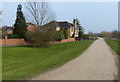
Houses and path next to the River Trent
The houses are on Musters Croft in the Colwick area of Nottingham.
Image: © Mat Fascione
Taken: 12 Mar 2016
0.07 miles
2
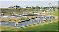
Holme Pierrepont National Water Sports Centre
The artificial slalom course at Holme Pierrepont National Water Sports Centre near Nottingham.
Image: © Martin Clark
Taken: Unknown
0.07 miles
3

Canoe slalom course
The canoe slalom course at The National Water Sports Centre near Nottingham.
Image: © Jon Clark
Taken: 1 Sep 2005
0.07 miles
4
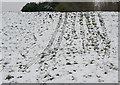
Toboggan run
A flood embankment has provided a short but steep run.
Image: © Alan Murray-Rust
Taken: 2 Feb 2009
0.07 miles
5
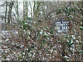
Hooked up
Fishing club notice in the brambles. Colwick Park seems a surprisingly distant location for waters to belong to a club based in Long Eaton, well to the west of Nottingham.
Image: © Alan Murray-Rust
Taken: 2 Feb 2009
0.08 miles
6
Standing water at Colwick Park
Following the extensive rainfall at the beginning of November this year. The area to the left of the bank represents the original meander of the River Trent before the new cut with Colwick Sluice was made.
Image: © Alan Murray-Rust
Taken: 10 Nov 2019
0.08 miles
7
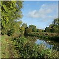
In Colwick Country Park
The water is following what was the natural course of the River Trent before the improvements of the 1950s. As a result it still forms the boundary between the City of Nottingham and Nottinghamshire.
Image: © Alan Murray-Rust
Taken: 15 Oct 2022
0.09 miles
8
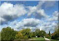
A 'Constable' cloudscape ? 2
This painting by John Constable https://commons.wikimedia.org/wiki/File:John_Constable_-_Extensive_Landscape_with_Grey_Clouds_-_Google_Art_Project.jpg gives an immediate comparison
Image: © Alan Murray-Rust
Taken: 15 Oct 2022
0.09 miles
9
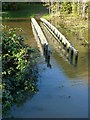
Footford at Colwick Park
Thigh-boots or waders would be need to cross the 'bridge' with the River Trent at this level.
Image: © Alan Murray-Rust
Taken: 10 Nov 2019
0.10 miles
10
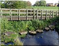
Footbridge and stepping stones
Until around 2015, the stepping stones were the only means of crossing.
Image: © Alan Murray-Rust
Taken: 15 Oct 2022
0.10 miles