IMAGES TAKEN NEAR TO
Valeside Gardens, NOTTINGHAM, NG4 2EP
Introduction
This page details the photographs taken nearby to Valeside Gardens, NG4 2EP by members of the Geograph project.
The Geograph project started in 2005 with the aim of publishing, organising and preserving representative images for every square kilometre of Great Britain, Ireland and the Isle of Man.

There are currently over 7.5m images from over14,400 individuals and you can help contribute to the project by visiting https://www.geograph.org.uk
Image Map
Images are licensed for reuse under creativecommons.org/licenses/by-sa/2.0
Notes
- Clicking on the map will re-center to the selected point.
- The higher the marker number, the further away the image location is from the centre of the postcode.
Image Listing (38 Images Found)
Images are licensed for reuse under creativecommons.org/licenses/by-sa/2.0
Image
Details
Distance
2
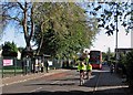
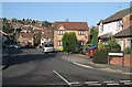
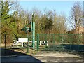
Colwick: cyclists and a 44 bus in Vale Road
The city-bound bus is approaching its next stop. St John the Baptist C of E Primary School is behind the green fence on the left.
Image: © John Sutton
Taken: 23 Sep 2015
0.10 miles
3
A school with an aeroplane
There can't be many schools with an aeroplance in their grounds: St John the Baptist C of E Primary School in Colwick Vale is one. For another view of it, see Alan Murray Rust's Image This picture was taken through the perimeter fence from the footpath to Bakersfield.
Image: © John Sutton
Taken: 23 Sep 2015
0.12 miles
4
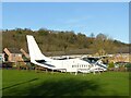
Still flying!
See https://www.geograph.org.uk/photo/3902717 for more information. Since that view was taken, the aeroplane has had a repaint, removing the registration lettering, and has also lost its propeller blades.
Image: © Alan Murray-Rust
Taken: 25 Dec 2020
0.13 miles
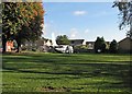
5
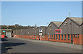
Factories, Colwick Industrial Estate
Part of a large purpose-built industrial estate of the post-war period.
Image: © Alan Murray-Rust
Taken: 14 Jan 2007
0.13 miles
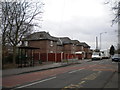
6
Modern housing on Vale Road
Late 20th century housing on a former industrial site.
Image: © Alan Murray-Rust
Taken: 25 Dec 2020
0.14 miles
7
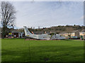
Flying school?
This Short 360 aeroplane was installed at St John the Baptist C of E School in Colwick as an additional classroom in 2011. Registered G-SSWD it was once operated by the Exeter based Streamline Airways.
Image: © Alan Murray-Rust
Taken: 16 Mar 2014
0.15 miles
8
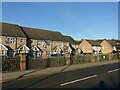
Lawrence Avenue, Colwick.
The Lawrence furniture factory was a major landmark in the area, now replaced by this housing development; the name lives on.
Image: © Alan Murray-Rust
Taken: 14 Jan 2007
0.16 miles
9
Colwick Vale sewage pumping station
A very necessary feature of the flat alluvial lands close to the River Trent, with the main treatment works at a higher level than the sewers.
Image: © Alan Murray-Rust
Taken: 25 Dec 2020
0.16 miles
10
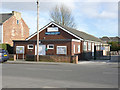
Colwick Village Hall
The Nottingham suburb of Colwick is rediscovering itself as a village community, and was awarded village status in 2008.
Image: © Alan Murray-Rust
Taken: 16 Mar 2014
0.16 miles