IMAGES TAKEN NEAR TO
Furzebrook Road, NOTTINGHAM, NG4 2BX
Introduction
This page details the photographs taken nearby to Furzebrook Road, NG4 2BX by members of the Geograph project.
The Geograph project started in 2005 with the aim of publishing, organising and preserving representative images for every square kilometre of Great Britain, Ireland and the Isle of Man.

There are currently over 7.5m images from over14,400 individuals and you can help contribute to the project by visiting https://www.geograph.org.uk
Image Map
Images are licensed for reuse under creativecommons.org/licenses/by-sa/2.0
Notes
- Clicking on the map will re-center to the selected point.
- The higher the marker number, the further away the image location is from the centre of the postcode.
Image Listing (31 Images Found)
Images are licensed for reuse under creativecommons.org/licenses/by-sa/2.0
Image
Details
Distance
1
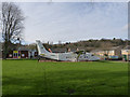
Flying school?
This Short 360 aeroplane was installed at St John the Baptist C of E School in Colwick as an additional classroom in 2011. Registered G-SSWD it was once operated by the Exeter based Streamline Airways.
Image: © Alan Murray-Rust
Taken: 16 Mar 2014
0.02 miles
2
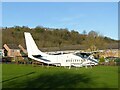
Still flying!
See https://www.geograph.org.uk/photo/3902717 for more information. Since that view was taken, the aeroplane has had a repaint, removing the registration lettering, and has also lost its propeller blades.
Image: © Alan Murray-Rust
Taken: 25 Dec 2020
0.03 miles
3
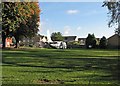
A school with an aeroplane
There can't be many schools with an aeroplance in their grounds: St John the Baptist C of E Primary School in Colwick Vale is one. For another view of it, see Alan Murray Rust's Image This picture was taken through the perimeter fence from the footpath to Bakersfield.
Image: © John Sutton
Taken: 23 Sep 2015
0.03 miles
4
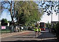
Colwick: cyclists and a 44 bus in Vale Road
The city-bound bus is approaching its next stop. St John the Baptist C of E Primary School is behind the green fence on the left.
Image: © John Sutton
Taken: 23 Sep 2015
0.04 miles
5
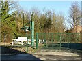
Colwick Vale sewage pumping station
A very necessary feature of the flat alluvial lands close to the River Trent, with the main treatment works at a higher level than the sewers.
Image: © Alan Murray-Rust
Taken: 25 Dec 2020
0.06 miles
6
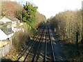
Looking east from the 'Tin Bridge' ? 2020
The same viewpoint as https://www.geograph.org.uk/photo/3902719 .
On that picture I commented about the position of the former GNR lines being identified by lower tree growth. These trees have now grown to a height which means that difference is no longer identifiable.
The view can only be obtained by holding the camera above the 2 metre high solid parapet of the footbridge.
Image: © Alan Murray-Rust
Taken: 25 Dec 2020
0.07 miles
7
Looking east from the 'Tin Bridge'
The line is the former Midland Railway route between Nottingham and Lincoln. At one time there was a second pair of lines where the lower vegetation to the right has now grown. This was the Great Northern Railway route between Nottingham and Grantham. Historically there was no connection between the two at this point but with the reduction of coal traffic the lines were rationalised. The GNR tracks were removed in the 1970s and the junction installed for trains towards Grantham.
Image: © Alan Murray-Rust
Taken: 16 Mar 2014
0.07 miles
8
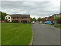
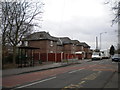
Hotspur Drive, Netherfield
Late 20th century housing development on former industrial land.
Image: © Alan Murray-Rust
Taken: 23 May 2021
0.07 miles
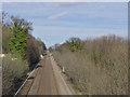
10
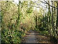
Midland Wood Cycle Route
The wood doesn't have a name on any OS mapping, and the name may have been invented when the path was improved as a cycleway in recent times. The path follows a narrow strip between the railway on the right and the steep scarp on the left, colonised by traditional broadleaf woodland and representing the edge of the River Trent's alluvial plain.
Image: © Alan Murray-Rust
Taken: 17 Dec 2020
0.08 miles