IMAGES TAKEN NEAR TO
Private Road 1, NOTTINGHAM, NG4 2AN
Introduction
This page details the photographs taken nearby to Private Road 1, NG4 2AN by members of the Geograph project.
The Geograph project started in 2005 with the aim of publishing, organising and preserving representative images for every square kilometre of Great Britain, Ireland and the Isle of Man.

There are currently over 7.5m images from over14,400 individuals and you can help contribute to the project by visiting https://www.geograph.org.uk
Image Map
Images are licensed for reuse under creativecommons.org/licenses/by-sa/2.0
Notes
- Clicking on the map will re-center to the selected point.
- The higher the marker number, the further away the image location is from the centre of the postcode.
Image Listing (22 Images Found)
Images are licensed for reuse under creativecommons.org/licenses/by-sa/2.0
Image
Details
Distance
2
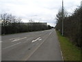
Road No1, Colwick Industrial Estate, Nottingham
Recreating this 'First' for the square https://www.geograph.org.uk/photo/43295
Image: © Alan Murray-Rust
Taken: 23 May 2021
0.07 miles
3
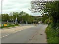
Road No1, Colwick Industrial Estate, Nottingham
at the junction of Colwick Loop Road
Image: © Tom Courtney
Taken: 26 Aug 2005
0.12 miles
4

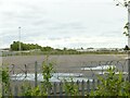
The site of Colwick oil terminal
Formerly there was a whole series of oil storage tanks here. https://www.geograph.org.uk/photo/312665
Image: © Alan Murray-Rust
Taken: 23 May 2021
0.12 miles
5
The site of Colwick oil terminal
Formerly there was a whole series of oil storage tanks here. https://www.geograph.org.uk/photo/312665 is the view in the opposite direction from the bridge over the railway.
Image: © Alan Murray-Rust
Taken: 23 May 2021
0.14 miles
6
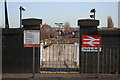
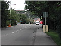
Netherfield Station
Formerly Netherfield and Colwick, on the Nottingham to Grantham line. Possibly the ultimate in minimal Station entrances.
Image: © Alan Murray-Rust
Taken: 14 Jan 2007
0.15 miles
7
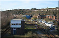
Netherfield Junction
A (relatively!) modern signal box, built post-nationalisation.
Image: © Alan Murray-Rust
Taken: 14 Jan 2007
0.15 miles
8
Netherfield Station: the overgrown end of the platform
The station has a huge island platform, little of which is now used. The post-war houses are on Meadow Road.
Image: © John Sutton
Taken: 22 Apr 2009
0.15 miles
10
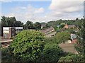
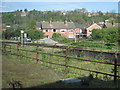
West from Netherfield
A view from the bridge which carries Chaworth Road over Netherfield Station, with Colwick Woods on the skyline. This is the Great Northern Line from Grantham, which originally ran parallel to and to the south of the Midland line from Newark and Lincoln, which it now joins, as far as Trent Lane. The signal box on the left (a 1960 replacement for the original) is surplus to requirements following the resignalling of Nottingham Midland Station and its approaches. The red-brick house to the right was once the Netherfield & Colwick Stationmaster's House.
Image: © John Sutton
Taken: 22 Aug 2013
0.17 miles