IMAGES TAKEN NEAR TO
Ernest Road, NOTTINGHAM, NG4 1LZ
Introduction
This page details the photographs taken nearby to Ernest Road, NG4 1LZ by members of the Geograph project.
The Geograph project started in 2005 with the aim of publishing, organising and preserving representative images for every square kilometre of Great Britain, Ireland and the Isle of Man.

There are currently over 7.5m images from over14,400 individuals and you can help contribute to the project by visiting https://www.geograph.org.uk
Image Map
Images are licensed for reuse under creativecommons.org/licenses/by-sa/2.0
Notes
- Clicking on the map will re-center to the selected point.
- The higher the marker number, the further away the image location is from the centre of the postcode.
Image Listing (11 Images Found)
Images are licensed for reuse under creativecommons.org/licenses/by-sa/2.0
Image
Details
Distance
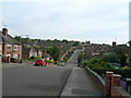
3
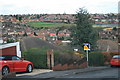
The descent into Carlton Valley
The area to the east of Nottingham abounds in steep hills where valleys have been cut into the relatively soft mudstones. This is Prospect Road.
Image: © Alan Murray-Rust
Taken: 18 Nov 2008
0.10 miles
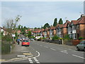
6
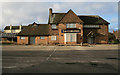
The Carlton Pub
Currently advertising for a new landlord
Image: © Martin Jones
Taken: 21 Dec 2008
0.18 miles
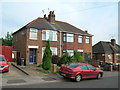
9
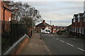
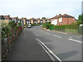
The top of Prospect Road
Porchester Junior School on the left
Image: © Martin Jones
Taken: 21 Dec 2008
0.23 miles
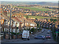
10
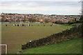
George V playing field
Sited on an old brick quarry, the red clay still shows through the grass. Photo taken from Standhill road, the grassed over spoil heap of Gedling coal pit is the highest point on the top left horizon.
Image: © Martin Jones
Taken: 21 Dec 2008
0.24 miles