IMAGES TAKEN NEAR TO
Moreland Court, NOTTINGHAM, NG4 1GS
Introduction
This page details the photographs taken nearby to Moreland Court, NG4 1GS by members of the Geograph project.
The Geograph project started in 2005 with the aim of publishing, organising and preserving representative images for every square kilometre of Great Britain, Ireland and the Isle of Man.

There are currently over 7.5m images from over14,400 individuals and you can help contribute to the project by visiting https://www.geograph.org.uk
Image Map
Images are licensed for reuse under creativecommons.org/licenses/by-sa/2.0
Notes
- Clicking on the map will re-center to the selected point.
- The higher the marker number, the further away the image location is from the centre of the postcode.
Image Listing (39 Images Found)
Images are licensed for reuse under creativecommons.org/licenses/by-sa/2.0
Image
Details
Distance
1
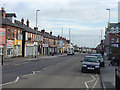
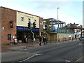
Carlton Hill shops
A local shopping centre which still has a respectable variety of shops. The shut-up appearance here is simply because it was a Sunday.
Image: © Alan Murray-Rust
Taken: 27 Jan 2008
0.06 miles
3
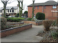
Garden for the blind
This little garden in the Carlton Hill shopping area features herbs and other scented plants which can be enjoyed by people with limited or no sight. The raised beds have been created with wheelchair users in mind. During the Christmas period the circular bed to the left is home to the local Council Christmas Tree.
Image: © Alan Murray-Rust
Taken: 27 Jan 2008
0.09 miles
4
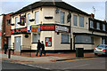
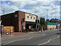
The Toby Jug
Closed pub on the corner of Cornhill Road and Carlton Hill.
Image: © David Lally
Taken: 6 Mar 2010
0.09 miles
5
Gain one, lose one, lose one, gain one
See http://www.geograph.org.uk/photo/2427648
The Wetherspoons pub is housed in a former Co-operative supermarket building. The new building to its right is on the site of the former Toby Jug pub, and is to be - a supermarket!
Image: © Alan Murray-Rust
Taken: 4 Dec 2011
0.10 miles
6
Gain one, lose one
The Free Man is a new Wetherspoon's pub created in a former Co-operative supermarket. The hoarding beyond surrounds the site of the now demolished Toby Jug http://www.geograph.org.uk/photo/1739838 . This had closed before The Free Man opened.
Image: © Alan Murray-Rust
Taken: 24 May 2011
0.10 miles
7
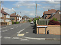
Northdale Road
Virtually the roads in this area incorporate -dale in their name. This is Northdale Road seen from Sunnydale Road. The whole area is typical tween-wars suburbia.
Image: © Alan Murray-Rust
Taken: 20 Jun 2008
0.12 miles
8
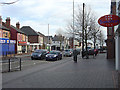
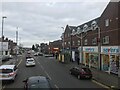
Carlton Hill shops
A local shopping centre which still has a respectable variety of shops. Not many of the shops actually open on Sundays which is why it looks a bit deserted. The wide pavements mean that shopping is more relaxed than in many areas. Although historically much of this area belonged to the frontagers, the local Gedling Borough Council has modernised the paving and introduced trees and benches. Some businesses still extend onto the frontage either to display their wares or for alfresco refreshments.
Image: © Alan Murray-Rust
Taken: 27 Jan 2008
0.12 miles
9
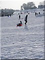
On the piste
The landscaped slopes of the former brickyard, now Carlton Hill Recreation Ground, are ideal for tobogganing, especially when the snow is powdery. There was even one young lady on skis.
Image: © Alan Murray-Rust
Taken: 5 Feb 2012
0.13 miles
