1
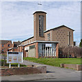
Carlton St John the Baptist Church
Built in 1958 to the design of architects Broadhead and Royle to serve the Bakersfields area in the east of Nottingham. The bricks were hand made from a brickworks in Loughborough. Southwell Churches Project entry: http://southwellchurches.nottingham.ac.uk/carlton-st-john-baptist/hintro.php
Image: © Alan Murray-Rust
Taken: 16 Mar 2014
0.03 miles
2
St John the Baptist Carlton, north side of Oakdale Road
Image: © Roger Templeman
Taken: 26 Sep 2022
0.03 miles
3
Church of St John the Baptist, Carlton
A repeat of my 2014 view https://www.geograph.org.uk/photo/3902694 , but in lighting conditions which made it impossible to resist. Even so, there are significant changes when you look carefully – the main window in the porch has been renewed with a different pattern of glazing bars, as has the tall side window in the end of the nave. For more details, see https://southwellchurches.nottingham.ac.uk/carlton-st-john-baptist/hintro.php
Image: © Alan Murray-Rust
Taken: 25 Dec 2020
0.04 miles
4
Junction Douglas Ave/ Oakdale Road, Carlton, Nottingham
Recreating this 'First' for the square https://www.geograph.org.uk/photo/43300 . The house on the right has lost its odd projecting windows, and the street name sign in the foreground has disappeared.
Image: © Alan Murray-Rust
Taken: 23 May 2021
0.05 miles
5
Looking west along Southdale Drive
Image: © Luke Shaw
Taken: 26 Sep 2022
0.06 miles
6
Nos. 248 and 246 Oakdale Road
#248 is Jazz's Convenience Store, #246 Remedy Health & Beauty Treatments. There is an Ordnance Survey benchmark
Image on the near corner, right hand face, of #246.
Image: © Roger Templeman
Taken: 26 Sep 2022
0.07 miles
7
Benchmark on side of jut on NW face of #246 Oakdale Road
Ordnance Survey cut mark benchmark levelled at 73.484m above Newlyn Datum verified 1962
Image: © Roger Templeman
Taken: 26 Sep 2022
0.07 miles
8
Houses at junction in Southdale Drive
Image: © Roger Templeman
Taken: 26 Sep 2022
0.07 miles
9
Junction Southdale Drive/ Oakdale Road, Carlton, Nottingham
Recreating this original 'First' for square SK6141 https://www.geograph.org.uk/photo/43303 which turns out to be in the neighbouring square SK6140 . The small flower beds have been planted with lower maintenance plants, and there is a new wall on the left hand edge of the picture. The original view originally incorrectly referred to 'Southdale Road' rather than 'Southdale Drive'.
Image: © Alan Murray-Rust
Taken: 23 May 2021
0.07 miles
10
Junction Southdale Drive/ Oakdale Road, Carlton, Nottingham
Image: © Tom Courtney
Taken: 26 Aug 2005
0.07 miles


