IMAGES TAKEN NEAR TO
Southcliffe Road, NOTTINGHAM, NG4 1EP
Introduction
This page details the photographs taken nearby to Southcliffe Road, NG4 1EP by members of the Geograph project.
The Geograph project started in 2005 with the aim of publishing, organising and preserving representative images for every square kilometre of Great Britain, Ireland and the Isle of Man.

There are currently over 7.5m images from over14,400 individuals and you can help contribute to the project by visiting https://www.geograph.org.uk
Image Map
Images are licensed for reuse under creativecommons.org/licenses/by-sa/2.0
Notes
- Clicking on the map will re-center to the selected point.
- The higher the marker number, the further away the image location is from the centre of the postcode.
Image Listing (49 Images Found)
Images are licensed for reuse under creativecommons.org/licenses/by-sa/2.0
Image
Details
Distance
1
The buses are still running
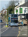
During the COVID-19 lockdown Nottingham City Transport is running a very reduced service on a small selection of routes, essentially those included in the 'goto' branding. The selection does however include the rural route out to Southwell, seen here on Carlton Hill, and Loughborough. The revised timetable introduced on 5 April 2020 requires 42 buses, less than 20% of the normal weekday output.
Image: © Alan Murray-Rust
Taken: 5 Apr 2020
0.05 miles
2
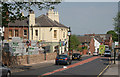
The Nags Head
A suburban pub which seems to have survived all the repositioning of styles of the last 2 decades. The illuminated speed sign just beyond the pub had only been operational for a couple of days when this view was taken.
Image: © Alan Murray-Rust
Taken: 8 May 2008
0.06 miles
3
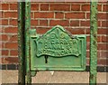
Gate lock with makers name, Carlton Hill
On the gateway to the house on the left of this view https://www.geograph.org.uk/photo/793883 . A nice piece of Victorian cast iron.
Image: © Alan Murray-Rust
Taken: 16 May 2020
0.08 miles
4
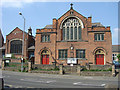
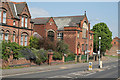
Churches on Carlton Hill
The larger one is Main Street Methodist Church. The church takes its name from the earlier name of the road; it became Carlton Hill during the early years of the 20th Century. The building to the left of it was originally the church hall, but is now the Orthodox Church of the Holy Transfiguration.
Image: © Alan Murray-Rust
Taken: 8 May 2008
0.09 miles
5
Churches on Carlton Hill
The larger one is Main Street Methodist Church. Although the road is now called Carlton Hill this part of it was formerly known as Main Street, and the church has retained the original name. The building to this side of it was originally the church hall, but is now the Orthodox Church of the Holy Transfiguration.
Image: © Alan Murray-Rust
Taken: 8 May 2008
0.11 miles
6
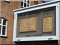
Sign of the times
No services are taking place during the COVID-19 lockdown.
Image: © Alan Murray-Rust
Taken: 5 Apr 2020
0.11 miles
7
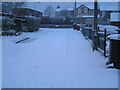
Snowed in
The cul-de-sac leading to the main road is treacherous after overnight snow.
Image: © Karen Chantrey Wood
Taken: 5 Feb 2009
0.15 miles
8
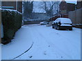
The junction of Celia Drive and Carlton Hill
Carlton Hill is a busy thoroughfare into Nottingham. Once the A612, it was redesignated and in recent years has had various traffic calming devices installed. On this morning though, nature had its own calming device...the snow
Image: © Karen Chantrey Wood
Taken: 5 Feb 2009
0.15 miles
10
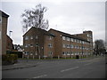
Foxhill Court, Carlton
Located on Foxhill Road East a little way to the west of Carlton town centre.
Image: © Richard Vince
Taken: 13 Apr 2013
0.17 miles