IMAGES TAKEN NEAR TO
Kensington Gardens, NOTTINGHAM, NG4 1DZ
Introduction
This page details the photographs taken nearby to Kensington Gardens, NG4 1DZ by members of the Geograph project.
The Geograph project started in 2005 with the aim of publishing, organising and preserving representative images for every square kilometre of Great Britain, Ireland and the Isle of Man.

There are currently over 7.5m images from over14,400 individuals and you can help contribute to the project by visiting https://www.geograph.org.uk
Image Map
Images are licensed for reuse under creativecommons.org/licenses/by-sa/2.0
Notes
- Clicking on the map will re-center to the selected point.
- The higher the marker number, the further away the image location is from the centre of the postcode.
Image Listing (27 Images Found)
Images are licensed for reuse under creativecommons.org/licenses/by-sa/2.0
Image
Details
Distance
1
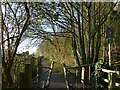
Midland Wood Cycle Route
The wood doesn't have a name on any OS mapping, and the name may have been invented when the path was improved as a cycleway in recent times. The path follows a narrow strip between the railway on the left and the steep scarp on the right, colonised by traditional broadleaf woodland and representing the edge of the River Trent's alluvial plain.
Image: © Alan Murray-Rust
Taken: 17 Dec 2020
0.10 miles
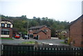
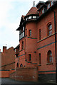
5
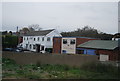
Carlton Laundry
A laundry and dye works building on Marhill Road / Primrose Street.
This is a Watson Fothergill design from 1899. Its listing (Grade II) description currently describes it as being in use as a print works. It has however now been converted into apartments.
List Entry Number:1236194 https://historicengland.org.uk/listing/the-list/list-entry/1236194?section=official-list-entry
Image: © David Lally
Taken: 6 Mar 2010
0.16 miles
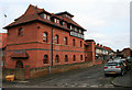
6
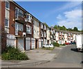
Carlton Laundry
A laundry and dye works building on Marhill Road / Primrose Street.
This is a Watson Fothergill design from 1899. Its listing (Grade II status) description currently describes it as being in use as a print works. It has however now been converted into apartments.
In the near corner is the base of the, now removed, chimney. To the left is a new build apartment block built in a similar style, presumably at the same time that the laundry was converted.
List Entry Number:1236194 https://historicengland.org.uk/listing/the-list/list-entry/1236194?section=official-list-entry
Image: © David Lally
Taken: 6 Mar 2010
0.16 miles
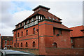
7
Ex Laundry
A laundry and dye works building on Marhill Road / Primrose Street.
This is a Watson Fothergill design from 1899. Its listing (Grade II) description currently describes it as being in use as a print works. It has however now been converted into apartments.
Image: © David Lally
Taken: 6 Mar 2010
0.16 miles
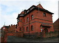
8
Laundry tower
A laundry and dye works building on Marhill Road / Primrose Street.
This is a Watson Fothergill design from 1899. Its listing (Grade II) description currently describes it as being in use as a print works. It has however now been converted into apartments.
Image: © David Lally
Taken: 6 Mar 2010
0.16 miles
9
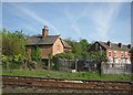
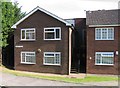
Netherfield: Station Master's House
The Great Northern Railway built a substantial detached house - now abandoned and boarded up - for the Station Master at Netherfield. The Victorian terrace is on the north side of Meadow Road.
Image: © John Sutton
Taken: 22 Apr 2009
0.18 miles